
Topografische Karte São José do Rio Preto
Interaktive Karte
Klicken Sie auf die Karte, um die Höhe anzuzeigen.
Über diese Karte
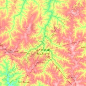
Name: Topografische Karte São José do Rio Preto, Höhe, Relief.
Durchschnittliche Höhe: 527 m
Minimale Höhe: 430 m
Maximale Höhe: 602 m
São José do Rio Preto is located in northwest of the state of São Paulo in a region between the rivers Grande, Paraná and Tietê. The ecosystem in the region lies between the Cerrado (Brazilian savanna) with traces of the Atlantic Forest. Topographycally, it is characterized by a slightly undulated relief, with a medium elevation of 489 m (1,604 ft).