
Topografische Karte Vitoria-Gasteiz
Interaktive Karte
Klicken Sie auf die Karte, um die Höhe anzuzeigen.
Über diese Karte
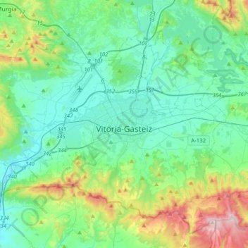
Name: Topografische Karte Vitoria-Gasteiz, Höhe, Relief.
Durchschnittliche Höhe: 626 m
Minimale Höhe: 475 m
Maximale Höhe: 1.167 m
Vitoria-Gasteiz has an oceanic climate (Köppen climate classification: Cfb). Winters are much cooler than in lowland coastal areas, whilst summers are similar in terms of high temperatures, with cool nights due to the elevation. Summers show a significant influence of mediterranean precipitation patterns, but enough precipitation usually occurs to remain marine in nature. Sunshine levels are low by Spanish standards and the climate is humid year-round.