
Spenden
Rüsten Sie sich für Ihr nächstes Abenteuer:
Als Amazon-Partner erhält diese Website eine Provision für qualifizierte Käufe, ohne zusätzliche Kosten für Sie.
Topografische Karte Santa Barbara
Klicken Sie auf die Karte, um die Höhe anzuzeigen.
Spenden
Rüsten Sie sich für Ihr nächstes Abenteuer:
Als Amazon-Partner erhält diese Website eine Provision für qualifizierte Käufe, ohne zusätzliche Kosten für Sie.
Santa Barbara
Annual rainfall totals are highly variable and in exceptional years (like 1940–1941 and 1997–1998) over 40 inches (1,000 mm) of rain have fallen in a year, but in dry seasons less than 6 inches (150 mm) is not unheard of. Snow sometimes covers higher elevations of the Santa Ynez Mountains but is extremely rare in the city itself. The most recent accumulating snow to fall near sea level was in January 1949, when approximately 2 inches (5.1 cm) fell in the city.
Spenden
Rüsten Sie sich für Ihr nächstes Abenteuer:
Als Amazon-Partner erhält diese Website eine Provision für qualifizierte Käufe, ohne zusätzliche Kosten für Sie.
Über diese Karte
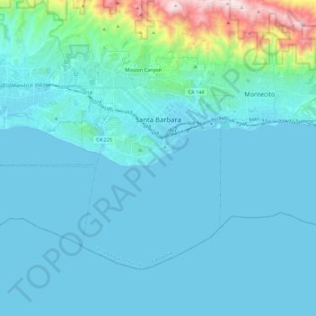
Name: Topografische Karte Santa Barbara, Höhe, Relief.
Durchschnittliche Höhe: 119 m
Minimale Höhe: -1 m
Maximale Höhe: 1.155 m
Spenden
Rüsten Sie sich für Ihr nächstes Abenteuer:
Als Amazon-Partner erhält diese Website eine Provision für qualifizierte Käufe, ohne zusätzliche Kosten für Sie.
Andere topografische Karten
Klicken Sie auf eine Karte, um ihre Topografie, ihre Höhe und ihr Relief anzuzeigen.
Spenden
Rüsten Sie sich für Ihr nächstes Abenteuer:
Als Amazon-Partner erhält diese Website eine Provision für qualifizierte Käufe, ohne zusätzliche Kosten für Sie.
Vandenberg Village
United States > California > Santa Barbara County > Lompoc
Durchschnittliche Höhe: 132 m
Spenden
Rüsten Sie sich für Ihr nächstes Abenteuer:
Als Amazon-Partner erhält diese Website eine Provision für qualifizierte Käufe, ohne zusätzliche Kosten für Sie.
West Beach
United States > California > Santa Barbara County > Santa Barbara
Durchschnittliche Höhe: 8 m
Spenden
Rüsten Sie sich für Ihr nächstes Abenteuer:
Als Amazon-Partner erhält diese Website eine Provision für qualifizierte Käufe, ohne zusätzliche Kosten für Sie.
Jalama Beach County Park
United States > California > Santa Barbara County > Jalama
Durchschnittliche Höhe: 40 m
Spenden
Rüsten Sie sich für Ihr nächstes Abenteuer:
Als Amazon-Partner erhält diese Website eine Provision für qualifizierte Käufe, ohne zusätzliche Kosten für Sie.
Shoreline Park
United States > California > Santa Barbara County > Santa Barbara
Durchschnittliche Höhe: 21 m
North Santa Maria
United States > California > Santa Barbara County > Santa Maria
Durchschnittliche Höhe: 65 m
Haskell's Beach
United States > California > Santa Barbara County > Goleta
Durchschnittliche Höhe: 15 m
Spenden
Rüsten Sie sich für Ihr nächstes Abenteuer:
Als Amazon-Partner erhält diese Website eine Provision für qualifizierte Käufe, ohne zusätzliche Kosten für Sie.
Spenden
Rüsten Sie sich für Ihr nächstes Abenteuer:
Als Amazon-Partner erhält diese Website eine Provision für qualifizierte Käufe, ohne zusätzliche Kosten für Sie.
Santa Maria
United States > California > Santa Barbara County > Santa Maria
Durchschnittliche Höhe: 185 m
Las Positas Meadows
United States > California > Santa Barbara County > Santa Barbara
Durchschnittliche Höhe: 66 m