
Topografische Karte Île Sainte-Hélène
Interaktive Karte
Klicken Sie auf die Karte, um die Höhe anzuzeigen.
Über diese Karte
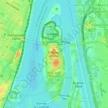
Name: Topografische Karte Île Sainte-Hélène, Höhe, Relief.
Durchschnittliche Höhe: 15 m
Minimale Höhe: 3 m
Maximale Höhe: 41 m
Elle est située immédiatement au sud-est de l'île de Montréal, elle mesure presque 3 km de longueur, 600 m de largeur et une trentaine de mètres d'altitude.
Andere topografische Karten
Klicken Sie auf eine Karte, um ihre Topografie, ihre Höhe und ihr Relief anzuzeigen.
Montréal
Canada > Québec > Agglomération de Montréal > Montréal
Montréal, Agglomération de Montréal, Montréal (06), Québec, H3B 1M7, Canada
Durchschnittliche Höhe: 30 m
Saint-Léonard
Canada > Québec > Agglomération de Montréal > Montréal
Saint-Léonard, Montréal, Agglomération de Montréal, Montréal (06), Québec, Canada
Durchschnittliche Höhe: 41 m
Parc Jean-Duceppe
Canada > Québec > Agglomération de Montréal > Montréal
Parc Jean-Duceppe, Petite-Côte, Rosemont–La Petite-Patrie, Montréal, Agglomération de Montréal, Montréal (06), Québec, Canada
Durchschnittliche Höhe: 48 m
Parc Hans-Selye
Canada > Québec > Agglomération de Montréal > Montréal
Parc Hans-Selye, Marc-Aurèle-Fortin, Rivière-des-Prairies–Pointe-aux-Trembles, Montréal, Agglomération de Montréal, Montréal (06), Québec, Canada
Durchschnittliche Höhe: 25 m
Île Bizard
Canada > Québec > Agglomération de Montréal > Montréal
Île Bizard, Montréal, Agglomération de Montréal, Montréal (06), Québec, Canada
Durchschnittliche Höhe: 29 m
Mont-Royal
Canada > Québec > Agglomération de Montréal > Montréal
Mont-Royal, Montréal, Agglomération de Montréal, Montréal (06), Québec, H3A 2B7, Canada
Durchschnittliche Höhe: 111 m
Plateau Mont-Royal
Canada > Québec > Agglomération de Montréal > Montréal
Plateau Mont-Royal, Montréal, Agglomération de Montréal, Montréal (06), Québec, Canada
Durchschnittliche Höhe: 70 m