
Topografische Karte 1st District of Patras - Arctic Sector
Interaktive Karte
Klicken Sie auf die Karte, um die Höhe anzuzeigen.
Über diese Karte
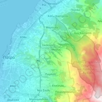
Name: Topografische Karte 1st District of Patras - Arctic Sector, Höhe, Relief.
Durchschnittliche Höhe: 375 m
Minimale Höhe: -3 m
Maximale Höhe: 1.840 m
Andere topografische Karten
Klicken Sie auf eine Karte, um ihre Topografie, ihre Höhe und ihr Relief anzuzeigen.
Kato Lousi
Greece > Peloponnese, Western Greece and the Ionian > Achaea Regional Unit > Municipality of Kalavryta
Kato Lousi, Municipality of Kalavryta, Achaea Regional Unit, Western Greece, Peloponnese, Western Greece and the Ionian, 250 01, Greece
Durchschnittliche Höhe: 1.172 m
Municipality of Kalavryta
Greece > Peloponnese, Western Greece and the Ionian > Achaea Regional Unit
Municipality of Kalavryta, Achaea Regional Unit, Western Greece, Peloponnese, Western Greece and the Ionian, Greece
Durchschnittliche Höhe: 975 m
Municipal Unit of Movri
Greece > Peloponnese, Western Greece and the Ionian > Achaea Regional Unit
Municipal Unit of Movri, Municipality of West Achaea, Achaea Regional Unit, Western Greece, Peloponnese, Western Greece and the Ionian, 250 05, Greece
Durchschnittliche Höhe: 55 m
Patras
Greece > Peloponnese, Western Greece and the Ionian > Achaea Regional Unit > Patras
Patras, Municipal Unit of Patras, Municipality of Patras, Achaea Regional Unit, Western Greece, Peloponnese, Western Greece and the Ionian, 26221, Greece
Durchschnittliche Höhe: 283 m