
Topografische Karte Roxborough
Interaktive Karte
Klicken Sie auf die Karte, um die Höhe anzuzeigen.
Über diese Karte
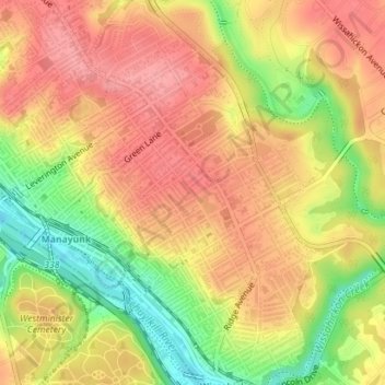
Name: Topografische Karte Roxborough, Höhe, Relief.
Durchschnittliche Höhe: 63 m
Minimale Höhe: 5 m
Maximale Höhe: 98 m
Since the 1950s, most of Philadelphia's major television and FM radio stations have located their transmission towers in Roxborough because of its hilly terrain and high elevation. The tallest of these towers, the American Tower, stands approximately 1,250 feet (381m) tall. Public television station "MiND", once called "WYBE", was also formerly located in Upper Roxborough, close to neighboring Andorra.
Andere topografische Karten
Klicken Sie auf eine Karte, um ihre Topografie, ihre Höhe und ihr Relief anzuzeigen.
Wister
United States > Pennsylvania > Philadelphia County > Philadelphia
Wister, Philadelphia, Philadelphia County, Pennsylvania, 19144, United States
Durchschnittliche Höhe: 66 m
Philadelphia
United States > Pennsylvania > Philadelphia County > Philadelphia
Philadelphia, Philadelphia County, Pennsylvania, 19110, United States
Durchschnittliche Höhe: 35 m
Center City
United States > Pennsylvania > Philadelphia County > Philadelphia
Center City, Philadelphia, Philadelphia County, Pennsylvania, United States
Durchschnittliche Höhe: 14 m
Aviv's Garden
United States > Pennsylvania > Philadelphia County > Philadelphia
Aviv's Garden, Southwest Center City, South Philadelphia, Philadelphia, Philadelphia County, Pennsylvania, United States
Durchschnittliche Höhe: 15 m
Penn Park
United States > Pennsylvania > Philadelphia County > Philadelphia
Penn Park, University City, Philadelphia, Philadelphia County, Pennsylvania, United States
Durchschnittliche Höhe: 17 m
Franklin Delano Roosevelt Park
United States > Pennsylvania > Philadelphia County > Philadelphia
Franklin Delano Roosevelt Park, South Philadelphia, Philadelphia, Philadelphia County, Pennsylvania, United States
Durchschnittliche Höhe: 5 m