
Topografische Karte Mount Tzouhalem
Interaktive Karte
Klicken Sie auf die Karte, um die Höhe anzuzeigen.
Über diese Karte
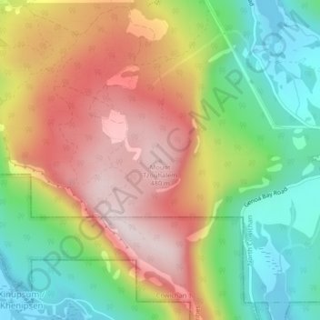
Name: Topografische Karte Mount Tzouhalem, Höhe, Relief.
Durchschnittliche Höhe: 233 m
Minimale Höhe: 0 m
Maximale Höhe: 492 m
The reserve, at middle elevations (120–280 metres) on the western side of the mountain, faces southwest and has strongly sloping, internally hilly terrain. The Tzuhalem area is a historical harvesting location for the Vancouver Island Coast Salish First Nations. The reserve is a camas harvesting site that was traditionally burned to increase yields and maintain the open, park-like habitat.
Andere topografische Karten
Klicken Sie auf eine Karte, um ihre Topografie, ihre Höhe und ihr Relief anzuzeigen.
Stoney Hill
Canada > British Columbia > Cowichan Valley Regional District > North Cowichan
Stoney Hill, North Cowichan, Cowichan Valley Regional District, British Columbia, V9L 5T7, Canada
Durchschnittliche Höhe: 78 m