
Topografische Karte Catoctin Mountain
Interaktive Karte
Klicken Sie auf die Karte, um die Höhe anzuzeigen.
Über diese Karte
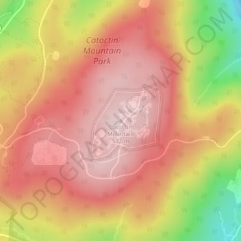
Name: Topografische Karte Catoctin Mountain, Höhe, Relief.
Durchschnittliche Höhe: 471 m
Minimale Höhe: 271 m
Maximale Höhe: 574 m
Catoctin Mountain traverses Frederick County, Maryland, and extends into northern Loudoun County, Virginia. It rises to its greatest elevation of 1,900 feet (580 m) above sea level just southwest of Cunningham Falls State Park and is transected by gaps at Braddock Heights (Fairview Pass), Point of Rocks on the Potomac River and Clarke's Gap west of Leesburg, as well as several other unnamed passes in Maryland and Virginia. The mountain is much lower in elevation in Virginia, reaching its highest peak just south of the Potomac at Furnace Mountain (891 feet/271 m) and with only one peak above 800 feet (240 m) south of Leesburg.
Andere topografische Karten
Klicken Sie auf eine Karte, um ihre Topografie, ihre Höhe und ihr Relief anzuzeigen.
Columbia
United States of America > Maryland > Columbia
Columbia, Howard County, Maryland, 21044, United States of America
Durchschnittliche Höhe: 110 m
Severna Park
United States of America > Maryland > Severna Park
Severna Park, Anne Arundel County, Maryland, United States of America
Durchschnittliche Höhe: 16 m
Chesapeake Bay
United States of America > Maryland
Chesapeake Bay, Dorchester County, Maryland, United States of America
Durchschnittliche Höhe: 0 m
Cheverly
United States of America > Maryland > Cheverly
Cheverly, Prince George's County, Maryland, United States of America
Durchschnittliche Höhe: 30 m
Sugarloaf Mountain
United States of America > Maryland
Sugarloaf Mountain, Frederick County, Maryland, 20842, United States of America
Durchschnittliche Höhe: 200 m
Merrimack Park
United States of America > Maryland > Bethesda > Merrimack Park
Merrimack Park, Bethesda, Montgomery County, Maryland, 20812, United States of America
Durchschnittliche Höhe: 79 m
Davidsonville
United States of America > Maryland > Davidsonville
Davidsonville, Anne Arundel County, Maryland, 21035, United States of America
Durchschnittliche Höhe: 37 m
Suitland
United States of America > Maryland > Suitland
Suitland, Prince George's County, Maryland, 20233, United States of America
Durchschnittliche Höhe: 70 m
Assawoman Bay
United States of America > Maryland
Assawoman Bay, Ocean City Expressway, Ocean Pines, Worcester County, Maryland, 21811, United States of America
Durchschnittliche Höhe: 1 m
Back River
United States of America > Maryland > Edgemere
Back River, Wharf Road, Tradepoint Atlantic, Sparrows Point, Edgemere, Baltimore County, Maryland, 21219, United States of America
Durchschnittliche Höhe: 4 m
Tall Timbers
United States of America > Maryland > Tall Timbers
Tall Timbers, Anne Arundel County, Maryland, 2108, United States of America
Durchschnittliche Höhe: 33 m
Seneca Creek State Park
United States of America > Maryland
Seneca Creek State Park, Montgomery County, Maryland, United States of America
Durchschnittliche Höhe: 99 m
Glenwood Heights
United States of America > Maryland > Easton > Glenwood Heights
Glenwood Heights, Easton, Talbot County, Maryland, 21601, United States of America
Durchschnittliche Höhe: 6 m
Myrtle Grove Wildlife Management Area
United States of America > Maryland > Hunters Brooke
Myrtle Grove Wildlife Management Area, Miller Hill Road, Hunters Brooke, Charles County, Maryland, 20646, United States of America
Durchschnittliche Höhe: 33 m
Piney Mountain
United States of America > Maryland
Piney Mountain, Frederick County, Maryland, 21780, United States of America
Durchschnittliche Höhe: 355 m
Chesapeake Forest
United States of America > Maryland > Waterview
Chesapeake Forest, Nanticoke Road, Waterview, Wicomico County, Maryland, 21814, United States of America
Durchschnittliche Höhe: 1 m
Running Brook Acres
United States of America > Maryland > Running Brook Acres
Running Brook Acres, Clarksburg, Montgomery County, Maryland, 20871, United States of America
Durchschnittliche Höhe: 173 m
Fulton
United States of America > Maryland > Fulton
Fulton, Howard County, Maryland, 20759, United States of America
Durchschnittliche Höhe: 127 m
Woodside Park
United States of America > Maryland > Silver Spring > Woodside Park
Woodside Park, Silver Spring, Montgomery County, Maryland, 20910, United States of America
Durchschnittliche Höhe: 96 m
Buena Vista
United States of America > Maryland > Seabrook > Buena Vista
Buena Vista, Seabrook, Prince George's County, Maryland, 20769, United States of America
Durchschnittliche Höhe: 47 m
Reid
United States of America > Maryland > Reid
Reid, Washington County, Maryland, 17263, United States of America
Durchschnittliche Höhe: 188 m
Bayberry
United States of America > Maryland > Bayberry
Bayberry, Anne Arundel County, Maryland, 21012, United States of America
Durchschnittliche Höhe: 8 m
Big Woods
United States of America > Maryland > Big Woods
Big Woods, Bel Air North, Harford County, Maryland, 21015, United States of America
Durchschnittliche Höhe: 107 m
Warren
United States of America > Maryland > The Lakes > Warren
Warren, The Lakes, Baltimore County, Maryland, 21030, United States of America
Durchschnittliche Höhe: 131 m
Bryans Road
United States of America > Maryland > Bryans Road > Bryans Road
Bryans Road, Charles County, Maryland, 20616, United States of America
Durchschnittliche Höhe: 35 m