
Topografische Karte Lamia
Interaktive Karte
Klicken Sie auf die Karte, um die Höhe anzuzeigen.
Über diese Karte
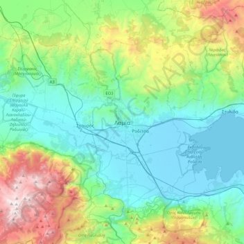
Name: Topografische Karte Lamia, Höhe, Relief.
Durchschnittliche Höhe: 534 m
Minimale Höhe: -4 m
Maximale Höhe: 2.141 m
Andere topografische Karten
Klicken Sie auf eine Karte, um ihre Topografie, ihre Höhe und ihr Relief anzuzeigen.
Komma
Greece > Thessaly and Central Greece > Phthiotis Regional Unit > Municipal Unit of Lamia
Komma, Municipal Unit of Lamia, Lamia Municipality, Phthiotis Regional Unit, Central Greece, Thessaly and Central Greece, 351 00, Greece
Durchschnittliche Höhe: 12 m
Ypati
Greece > Thessaly and Central Greece > Phthiotis Regional Unit > Δημοτική Ενότητα Υπάτης
Ypati, Δημοτική Ενότητα Υπάτης, Lamia Municipality, Phthiotis Regional Unit, Central Greece, Thessaly and Central Greece, 350 16, Greece
Durchschnittliche Höhe: 488 m
Varka
Greece > Thessaly and Central Greece > Phthiotis Regional Unit > Δημοτική Ενότητα Υπάτης > Loutra Ypatis
Varka, Κ. Λουτρών Υπάτης, Loutra Ypatis, Δημοτική Ενότητα Υπάτης, Lamia Municipality, Phthiotis Regional Unit, Central Greece, Thessaly and Central Greece, 350 16, Greece
Durchschnittliche Höhe: 166 m
Φούρνοι
Greece > Thessaly and Central Greece > Phthiotis Regional Unit > Αχλάδι
Φούρνοι, Κ. Ραχών, Αχλάδι, Stylida Municipality, Phthiotis Regional Unit, Central Greece, Thessaly and Central Greece, 353 00, Greece
Durchschnittliche Höhe: 22 m
Σκάρφεια
Greece > Thessaly and Central Greece > Phthiotis Regional Unit > Σκάρφεια
Σκάρφεια, Kamena Vourla Municipality, Phthiotis Regional Unit, Central Greece, Thessaly and Central Greece, 350 09, Greece
Durchschnittliche Höhe: 20 m
Phthiotis Regional Unit
Greece > Thessaly and Central Greece > Phthiotis Regional Unit
Phthiotis Regional Unit, Central Greece, Thessaly and Central Greece, Greece
Durchschnittliche Höhe: 480 m