
Topografische Karte La Petite Mazure
Interaktive Karte
Klicken Sie auf die Karte, um die Höhe anzuzeigen.
Über diese Karte
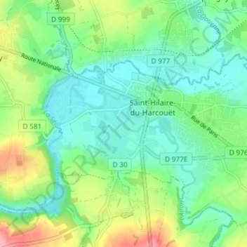
Name: Topografische Karte La Petite Mazure, Höhe, Relief.
Durchschnittliche Höhe: 90 m
Minimale Höhe: 57 m
Maximale Höhe: 165 m
Andere topografische Karten
Klicken Sie auf eine Karte, um ihre Topografie, ihre Höhe und ihr Relief anzuzeigen.
Saint-Hilaire-du-Harcouët
France > Normandie > Manche > Saint-Hilaire-du-Harcouët
Saint-Hilaire-du-Harcouët, Avranches, Manche, Normandie, France métropolitaine, 50600, France
Durchschnittliche Höhe: 92 m
La Huardière
France > Normandie > Manche > Saint-Hilaire-du-Harcouët
La Huardière, Saint-Hilaire-du-Harcouët, Avranches, Manche, Normandie, France métropolitaine, 50600, France
Durchschnittliche Höhe: 95 m
Saint-Martin-de-Landelles
France > Normandie > Manche > Saint-Hilaire-du-Harcouët
Saint-Martin-de-Landelles, Saint-Hilaire-du-Harcouët, Avranches, Manche, Normandie, France métropolitaine, 50730, France
Durchschnittliche Höhe: 129 m