
Topografische Karte San Bruno
Interaktive Karte
Klicken Sie auf die Karte, um die Höhe anzuzeigen.
San Bruno
According to the United States Census Bureau, the city has a total area of 5.5 square miles (14 km2), all of it land. The city spreads from the mostly flat lowlands near San Francisco Bay into the foothills of the Santa Cruz Mountains, which rise to more than 600 feet (180 m) above sea level in Crestmoor and more than 700 feet (210 m) above sea level in Portola Highlands. San Bruno City Hall sits at an official elevation of 41 feet (12.5 m) above sea level.
Über diese Karte
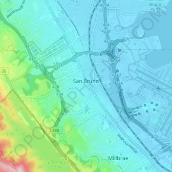
Name: Topografische Karte San Bruno, Höhe, Relief.
Durchschnittliche Höhe: 44 m
Minimale Höhe: -6 m
Maximale Höhe: 367 m