
Topografische Karte Gawler
Interaktive Karte
Klicken Sie auf die Karte, um die Höhe anzuzeigen.
Über diese Karte
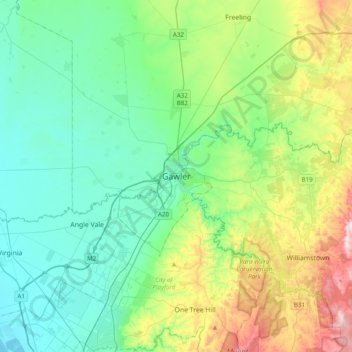
Name: Topografische Karte Gawler, Höhe, Relief.
Durchschnittliche Höhe: 142 m
Minimale Höhe: 2 m
Maximale Höhe: 564 m
Gawler is the oldest country town on the Australian mainland in the state of South Australia. It was named after the second Governor (British Vice-Regal representative) of the colony of South Australia, George Gawler. It is about 40–44 km (25–27 mi) north of the centre of the state capital, Adelaide, and is close to the major wine producing district of the Barossa Valley. Topographically, Gawler lies at the confluence of two tributaries of the Gawler River, the North and South Para rivers, where they emerge from a range of low hills.
Andere topografische Karten
Klicken Sie auf eine Karte, um ihre Topografie, ihre Höhe und ihr Relief anzuzeigen.
Gawler South
Australia > South Australia > Gawler
Gawler South, Gawler, Town of Gawler, South Australia, 5118, Australia
Durchschnittliche Höhe: 77 m