
Spenden
Rüsten Sie sich für Ihr nächstes Abenteuer:
Als Amazon-Partner erhält diese Website eine Provision für qualifizierte Käufe, ohne zusätzliche Kosten für Sie.
Topografische Karte Dahlgren Lake
Klicken Sie auf die Karte, um die Höhe anzuzeigen.
Spenden
Rüsten Sie sich für Ihr nächstes Abenteuer:
Als Amazon-Partner erhält diese Website eine Provision für qualifizierte Käufe, ohne zusätzliche Kosten für Sie.
Über diese Karte
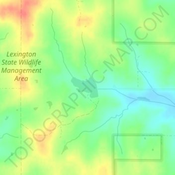
Name: Topografische Karte Dahlgren Lake, Höhe, Relief.
Ort: Dahlgren Lake, Cleveland County, Oklahoma, United States (35.05700 -97.20316 35.06027 -97.19800)
Durchschnittliche Höhe: 351 m
Minimale Höhe: 327 m
Maximale Höhe: 380 m
Spenden
Rüsten Sie sich für Ihr nächstes Abenteuer:
Als Amazon-Partner erhält diese Website eine Provision für qualifizierte Käufe, ohne zusätzliche Kosten für Sie.
Andere topografische Karten
Klicken Sie auf eine Karte, um ihre Topografie, ihre Höhe und ihr Relief anzuzeigen.
Norman
United States > Oklahoma > Cleveland County
Norman and the surrounding areas are mostly flat with an elevation near 1,171 feet (357 m). The terrain in the western section of Norman is prairie, while the eastern section, including the area surrounding Lake Thunderbird, consists of some 6,000 acres (24 km2) of lakes and Cross Timbers forest. The lowest…
Durchschnittliche Höhe: 358 m
Lake Thunderbird
United States > Oklahoma > Cleveland County > Norman > Little Axe
Durchschnittliche Höhe: 334 m
Southwest Oklahoma City Sludge Lagoon Dam
United States > Oklahoma > Cleveland County > Oklahoma City
Durchschnittliche Höhe: 348 m
Spenden
Rüsten Sie sich für Ihr nächstes Abenteuer:
Als Amazon-Partner erhält diese Website eine Provision für qualifizierte Käufe, ohne zusätzliche Kosten für Sie.
Norman
United States > Oklahoma > Cleveland County
Norman and the surrounding areas are mostly flat with an elevation near 1,171 ft (357 m). The terrain in the western section of Norman is prairie, while the eastern section, including the area surrounding Lake Thunderbird, consists of some 6,000 acres (24 km2) of lakes and Cross Timbers forest. The lowest…
Durchschnittliche Höhe: 358 m
Southwest Oklahoma City Sludge Lagoon Dam
United States > Oklahoma > Cleveland County > Oklahoma City
Durchschnittliche Höhe: 348 m
Norman
United States > Oklahoma > Cleveland County
Norman and the surrounding areas are mostly flat with an elevation near 1,171 ft (357 m). The terrain in the western section of Norman is prairie, while the eastern section, including the area surrounding Lake Thunderbird, consists of some 6,000 acres (24 km2) of lakes and Cross Timbers forest.
Durchschnittliche Höhe: 358 m
Spenden
Rüsten Sie sich für Ihr nächstes Abenteuer:
Als Amazon-Partner erhält diese Website eine Provision für qualifizierte Käufe, ohne zusätzliche Kosten für Sie.
Norman
United States > Oklahoma > Cleveland County
Norman and the surrounding areas are mostly flat with an elevation near 1,171 ft (357 m). The terrain in the western section of Norman is prairie, while the eastern section, including the area surrounding Lake Thunderbird, consists of some 6,000 acres (24 km2) of lakes and Cross Timbers forest.
Durchschnittliche Höhe: 358 m
Spenden
Rüsten Sie sich für Ihr nächstes Abenteuer:
Als Amazon-Partner erhält diese Website eine Provision für qualifizierte Käufe, ohne zusätzliche Kosten für Sie.