
Topografische Karte New Annan
Interaktive Karte
Klicken Sie auf die Karte, um die Höhe anzuzeigen.
Über diese Karte
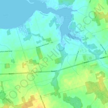
Name: Topografische Karte New Annan, Höhe, Relief.
Durchschnittliche Höhe: 10 m
Minimale Höhe: -2 m
Maximale Höhe: 30 m
Andere topografische Karten
Klicken Sie auf eine Karte, um ihre Topografie, ihre Höhe und ihr Relief anzuzeigen.
Fernwood
Canada > Prince Edward Island > Prince County
Fernwood, Prince County, Prince Edward Island, C0B 1C0, Canada
Durchschnittliche Höhe: 3 m
Kensington
Canada > Prince Edward Island > Prince County
Kensington, Prince County, Prince Edward Island, Canada
Durchschnittliche Höhe: 29 m
Greenmount
Canada > Prince Edward Island > Prince County > Greenmount
Greenmount, Rural Municipality of Greenmount-Montrose, Prince County, Prince Edward Island, Canada
Durchschnittliche Höhe: 19 m
Tyne Valley
Canada > Prince Edward Island > Prince County > Tyne Valley
Tyne Valley, Prince County, Prince Edward Island, C0B 2C0, Canada
Durchschnittliche Höhe: 19 m
Freeland
Canada > Prince Edward Island > Prince County > Freeland
Freeland, Rural Municipality of Lot 11 and Area, Prince County, Prince Edward Island, Canada
Durchschnittliche Höhe: 10 m
Alberton
Canada > Prince Edward Island > Prince County > Alberton
Alberton, Town of Alberton, Prince County, Prince Edward Island, C0B 1B0, Canada
Durchschnittliche Höhe: 7 m
Ebbsfleet
Canada > Prince Edward Island > Prince County
Ebbsfleet, Prince County, Prince Edward Island, Canada
Durchschnittliche Höhe: 14 m
Tryon
Canada > Prince Edward Island > Prince County
Tryon, Prince County, Prince Edward Island, Canada
Durchschnittliche Höhe: 11 m