
Topografische Karte Bruzolo
Interaktive Karte
Klicken Sie auf die Karte, um die Höhe anzuzeigen.
Über diese Karte
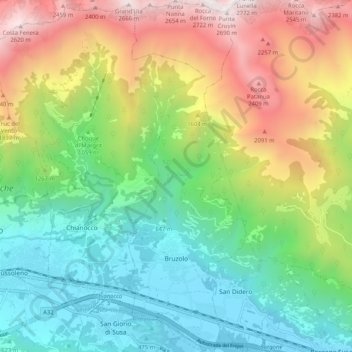
Name: Topografische Karte Bruzolo, Höhe, Relief.
Ort: Bruzolo, Torino, Piemont, Italy (45.12292 7.18170 45.19538 7.21655)
Durchschnittliche Höhe: 1.224 m
Minimale Höhe: 397 m
Maximale Höhe: 2.696 m
The town of Bruzolo is the main population centre of the commune and is its capoluogo. It stands to the left of the river Dora Riparia on an alluvial fan formed over the millennia by debris deposited by the Pissaglio and other minor torrents. The municipal territory also includes farmland and factories on the flood-plain of the Dora Riparia, and extends over the forested southern slopes of Punta Lunella, elevation 2,772 metres (9,094 ft), where there is a scattering of hamlets: Campobenedetto, Meisonardi, Comba, Bigiardi, Lunera, Coletto, Chiotetti, Seinera and Combette.