
Spenden
Rüsten Sie sich für Ihr nächstes Abenteuer:
Als Amazon-Partner erhält diese Website eine Provision für qualifizierte Käufe, ohne zusätzliche Kosten für Sie.
Topografische Karte Cayo Chiva
Klicken Sie auf die Karte, um die Höhe anzuzeigen.
Spenden
Rüsten Sie sich für Ihr nächstes Abenteuer:
Als Amazon-Partner erhält diese Website eine Provision für qualifizierte Käufe, ohne zusätzliche Kosten für Sie.
Über diese Karte
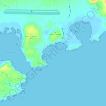
Name: Topografische Karte Cayo Chiva, Höhe, Relief.
Ort: Cayo Chiva, Puerto Rico, United States (18.10559 -65.41571 18.10608 -65.41541)
Durchschnittliche Höhe: 5 m
Minimale Höhe: -2 m
Maximale Höhe: 37 m
Spenden
Rüsten Sie sich für Ihr nächstes Abenteuer:
Als Amazon-Partner erhält diese Website eine Provision für qualifizierte Käufe, ohne zusätzliche Kosten für Sie.
Andere topografische Karten
Klicken Sie auf eine Karte, um ihre Topografie, ihre Höhe und ihr Relief anzuzeigen.
Puerto Rico
Puerto Rico features a diverse topography characterized by a mountainous interior, coastal plains, and stunning beaches. The island's central region is dominated by the Cordillera Central mountain range, which includes the highest peak, Cerro de Punta, rising to 4,390 feet (1,338 meters). These mountains…
Durchschnittliche Höhe: 65 m
Florida
Florida is the second smallest municipality of Puerto Rico, with an area of 10 square miles. As the only municipality in Puerto Rico that has its urban area within the northern karst region (sometimes referred as the Northern Karst Hills), it is surrounded by low elevation, red clay and limestone haystack…
Durchschnittliche Höhe: 200 m
Spenden
Rüsten Sie sich für Ihr nächstes Abenteuer:
Als Amazon-Partner erhält diese Website eine Provision für qualifizierte Käufe, ohne zusätzliche Kosten für Sie.
Ponce
United States > Puerto Rico > Ponce
Elevations include Cerro de Punta at 4,390 feet (1,338 m), the highest in Puerto Rico, located in Barrio Anón in the territory of the municipality of Ponce. Mount Jayuya, at 4,314 feet (1,315 m) is located on the boundary between Barrio Anón and Barrio Saliente in Jayuya. Cerro Maravilla, at nearly 3,970…
Durchschnittliche Höhe: 189 m
Spenden
Rüsten Sie sich für Ihr nächstes Abenteuer:
Als Amazon-Partner erhält diese Website eine Provision für qualifizierte Käufe, ohne zusätzliche Kosten für Sie.
Spenden
Rüsten Sie sich für Ihr nächstes Abenteuer:
Als Amazon-Partner erhält diese Website eine Provision für qualifizierte Käufe, ohne zusätzliche Kosten für Sie.
El Yunque National Forest
United States > Puerto Rico > Río Grande
Because Puerto Rico is located between the Tropic of Cancer and the Tropic of Capricorn, it has a tropical climate, more specifically a tropical rainforest climate, with higher elevations over 3,000 feet bordering on a subtropical highland climate. There is no distinct wet or dry season in El Yunque; it rains…
Durchschnittliche Höhe: 67 m
Adjuntas
United States > Puerto Rico > Adjuntas
Adjuntas features a tropical rainforest climate that borders on a subtropical highland climate. While the town technically features a tropical rainforest climate, due to its high elevation, the climate is noticeably cooler than the norm for this climate category. Summers are warm (83°-85 °F) in the daytime…
Durchschnittliche Höhe: 688 m
Spenden
Rüsten Sie sich für Ihr nächstes Abenteuer:
Als Amazon-Partner erhält diese Website eine Provision für qualifizierte Käufe, ohne zusätzliche Kosten für Sie.
Humacao
United States > Puerto Rico > Humacao > Humacao
Humacao is located in the southeast coast of Puerto Rico. It is bordered by the municipalities of Naguabo to the north, Yabucoa to the south, and Las Piedras to the west. The Atlantic Ocean borders the city in the east. Humacao is located in the region of the Eastern Coastal Plains, with most of its territory…
Durchschnittliche Höhe: 78 m
Cerro de Punta
United States > Puerto Rico > Ponce
The mountain is part of the Cordillera Central and is located on the border between the municipalities of Jayuya and Ponce. The access road to the point closest to the highest elevation is from the municipality of Jayuya. It is part of the Toro Negro Forest Reserve, and it has been described as "an alpine…
Durchschnittliche Höhe: 1.021 m
Spenden
Rüsten Sie sich für Ihr nächstes Abenteuer:
Als Amazon-Partner erhält diese Website eine Provision für qualifizierte Käufe, ohne zusätzliche Kosten für Sie.
Spenden
Rüsten Sie sich für Ihr nächstes Abenteuer:
Als Amazon-Partner erhält diese Website eine Provision für qualifizierte Käufe, ohne zusätzliche Kosten für Sie.
Spenden
Rüsten Sie sich für Ihr nächstes Abenteuer:
Als Amazon-Partner erhält diese Website eine Provision für qualifizierte Käufe, ohne zusätzliche Kosten für Sie.
Spenden
Rüsten Sie sich für Ihr nächstes Abenteuer:
Als Amazon-Partner erhält diese Website eine Provision für qualifizierte Käufe, ohne zusätzliche Kosten für Sie.
Spenden
Rüsten Sie sich für Ihr nächstes Abenteuer:
Als Amazon-Partner erhält diese Website eine Provision für qualifizierte Käufe, ohne zusätzliche Kosten für Sie.
Spenden
Rüsten Sie sich für Ihr nächstes Abenteuer:
Als Amazon-Partner erhält diese Website eine Provision für qualifizierte Käufe, ohne zusätzliche Kosten für Sie.
Spenden
Rüsten Sie sich für Ihr nächstes Abenteuer:
Als Amazon-Partner erhält diese Website eine Provision für qualifizierte Käufe, ohne zusätzliche Kosten für Sie.
Spenden
Rüsten Sie sich für Ihr nächstes Abenteuer:
Als Amazon-Partner erhält diese Website eine Provision für qualifizierte Käufe, ohne zusätzliche Kosten für Sie.
Spenden
Rüsten Sie sich für Ihr nächstes Abenteuer:
Als Amazon-Partner erhält diese Website eine Provision für qualifizierte Käufe, ohne zusätzliche Kosten für Sie.
Spenden
Rüsten Sie sich für Ihr nächstes Abenteuer:
Als Amazon-Partner erhält diese Website eine Provision für qualifizierte Käufe, ohne zusätzliche Kosten für Sie.
Spenden
Rüsten Sie sich für Ihr nächstes Abenteuer:
Als Amazon-Partner erhält diese Website eine Provision für qualifizierte Käufe, ohne zusätzliche Kosten für Sie.