
Topografische Karte Trapper Creek
Interaktive Karte
Klicken Sie auf die Karte, um die Höhe anzuzeigen.
Über diese Karte
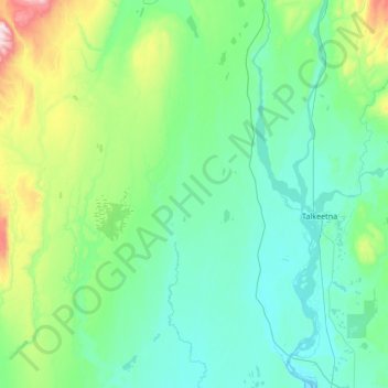
Name: Topografische Karte Trapper Creek, Höhe, Relief.
Durchschnittliche Höhe: 235 m
Minimale Höhe: 76 m
Maximale Höhe: 1.080 m
Trapper Creek is a community located in Matanuska-Susitna Borough at latitude 62.317 and longitude -150.231, with an elevation of 351 ft (107 m). It is at mile 114.5 on the Parks Highway, just south of Denali State Park. Trapper Creek is found at the intersection of Petersville Road and is spread out along the Parks Highway 15 miles (24 km) north of Talkeetna Junction. The Trapper Creek CDP extends west down the Petersville Road, which leads to mining, prospecting, and recreation country in the foothills of the Alaska Range.
Andere topografische Karten
Klicken Sie auf eine Karte, um ihre Topografie, ihre Höhe und ihr Relief anzuzeigen.
Mount Hunter
United States > Alaska > Matanuska-Susitna
Mount Hunter, Matanuska-Susitna, Alaska, United States
Durchschnittliche Höhe: 3.593 m
Talkeetna
United States > Alaska > Matanuska-Susitna
Talkeetna, Matanuska-Susitna, Alaska, 99676, United States
Durchschnittliche Höhe: 178 m
Wasilla
United States > Alaska > Matanuska-Susitna
Wasilla, Matanuska-Susitna, Alaska, United States
Durchschnittliche Höhe: 98 m
Palmer
United States > Alaska > Matanuska-Susitna
Palmer, Matanuska-Susitna, Alaska, 99645, United States
Durchschnittliche Höhe: 85 m
Palmer
United States > Alaska > Matanuska-Susitna > Palmer
Palmer, Matanuska-Susitna, Alaska, United States
Durchschnittliche Höhe: 349 m