
Topografische Karte Jacurso
Interaktive Karte
Klicken Sie auf die Karte, um die Höhe anzuzeigen.
Über diese Karte
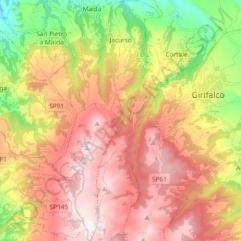
Name: Topografische Karte Jacurso, Höhe, Relief.
Ort: Jacurso, Catanzaro, Calabria, Italy (38.76297 16.34269 38.86227 16.40040)
Durchschnittliche Höhe: 542 m
Minimale Höhe: 89 m
Maximale Höhe: 928 m
Andere topografische Karten
Klicken Sie auf eine Karte, um ihre Topografie, ihre Höhe und ihr Relief anzuzeigen.
Catanzaro Lido
Italy > Calabria > Catanzaro > Catanzaro
Catanzaro Lido, Catanzaro, Calabria, Italy
Durchschnittliche Höhe: 31 m
Santa Caterina dello Ionio
Italy > Calabria > Catanzaro > Santa Caterina dello Ionio
Santa Caterina dello Ionio, Catanzaro, Calabria, Italy
Durchschnittliche Höhe: 293 m