
Spenden
Rüsten Sie sich für Ihr nächstes Abenteuer:
Als Amazon-Partner erhält diese Website eine Provision für qualifizierte Käufe, ohne zusätzliche Kosten für Sie.
Topografische Karte Distrikt Maseru
Klicken Sie auf die Karte, um die Höhe anzuzeigen.
Spenden
Rüsten Sie sich für Ihr nächstes Abenteuer:
Als Amazon-Partner erhält diese Website eine Provision für qualifizierte Käufe, ohne zusätzliche Kosten für Sie.
Distrikt Maseru
Während der Distrikt im Westen große Anteile der dicht bevölkerten lesothischen Lowlands enthält, liegt der östliche Teil des Distrikts in den Highlands oder Maloti Mountains, also oft schwer zugänglichen Bergregionen. Die niedrigste Höhe beträgt etwa 1400 Meter im Südwesten des Distrikts. Der höchste Berg des Distrikts ist der 2886 Meter hohe Machache, der der markanteste Teil der Front Range ist, der westlichsten Bergkette der Highlands.
Spenden
Rüsten Sie sich für Ihr nächstes Abenteuer:
Als Amazon-Partner erhält diese Website eine Provision für qualifizierte Käufe, ohne zusätzliche Kosten für Sie.
Über diese Karte
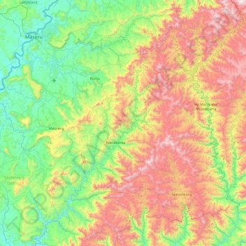
Name: Topografische Karte Distrikt Maseru, Höhe, Relief.
Ort: Distrikt Maseru, Lesotho (-29.96364 27.29503 -29.28201 28.31474)
Durchschnittliche Höhe: 2.019 m
Minimale Höhe: 1.438 m
Maximale Höhe: 3.091 m
Spenden
Rüsten Sie sich für Ihr nächstes Abenteuer:
Als Amazon-Partner erhält diese Website eine Provision für qualifizierte Käufe, ohne zusätzliche Kosten für Sie.
Andere topografische Karten
Klicken Sie auf eine Karte, um ihre Topografie, ihre Höhe und ihr Relief anzuzeigen.
Maseru
Im September 1988 besuchte Papst Johannes Paul II. die Stadt. Höhepunkt der Feier war die Seligsprechung von Father Joseph Gérard. Dieser war Missionar und hatte im 19. Jahrhundert großen Anteil an der Christianisierung der Basotho. Statt der erwarteten Million Gläubigen erschienen zur Papstmesse in Maseru…
Durchschnittliche Höhe: 1.606 m
Spenden
Rüsten Sie sich für Ihr nächstes Abenteuer:
Als Amazon-Partner erhält diese Website eine Provision für qualifizierte Käufe, ohne zusätzliche Kosten für Sie.