
Topografische Karte Mpumalanga
Interaktive Karte
Klicken Sie auf die Karte, um die Höhe anzuzeigen.
Über diese Karte
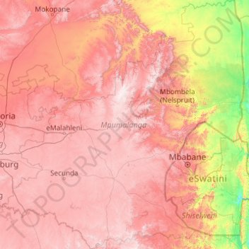
Name: Topografische Karte Mpumalanga, Höhe, Relief.
Ort: Mpumalanga, South Africa (-27.50615 28.24347 -23.98124 32.03372)
Durchschnittliche Höhe: 1.127 m
Minimale Höhe: 89 m
Maximale Höhe: 2.312 m
The Drakensberg escarpment divides Mpumalanga into a westerly half consisting mainly of high-altitude grassland called the Highveld and an eastern half situated in low-altitude subtropical Lowveld/Bushveld, mostly savanna habitat. The southern half of the Kruger National Park is in the latter region. The Drakensberg exceeds heights of 2000 m in most places, with this central region of Mpumalanga being very mountainous. These regions have alpine grasslands and small pockets of Afromontane forest. The Lowveld is relatively flat with interspersed rocky outcrops. The Lebombo Mountains form a low range in the far east, on the border with Mozambique.
Andere topografische Karten
Klicken Sie auf eine Karte, um ihre Topografie, ihre Höhe und ihr Relief anzuzeigen.
Cape Town
South Africa > Western Cape > City of Cape Town
Cape Town, City of Cape Town, Western Cape, 8001, South Africa
Durchschnittliche Höhe: 53 m
Deneysville
South Africa > Free State > Fezile Dabi District Municipality > Metsimaholo Local Municipality
Deneysville, Metsimaholo Local Municipality, Fezile Dabi District Municipality, Free State, South Africa
Durchschnittliche Höhe: 1.496 m
Cradock
South Africa > Eastern Cape > Chris Hani District Municipality > Inxuba Yethemba Local Municipality
Cradock, Inxuba Yethemba Local Municipality, Chris Hani District Municipality, Eastern Cape, 5880, South Africa
Durchschnittliche Höhe: 940 m
Map Position 36
South Africa > Eastern Cape > Sarah Baartman District Municipality > Sundays River Valley Local Municipality > Matyholweni Camp
Map Position 36, Sundays River Valley Ward 3, Matyholweni Camp, Sundays River Valley Local Municipality, Sarah Baartman District Municipality, Eastern Cape, South Africa
Durchschnittliche Höhe: 57 m
Ditsobotla Local Municipality
South Africa > North West > Ngaka Modiri Molema District Municipality
Ditsobotla Local Municipality, Ngaka Modiri Molema District Municipality, North West, 2740, South Africa
Durchschnittliche Höhe: 1.457 m
Kimberley
South Africa > Northern Cape > Frances Baard District Municipality > Kimberley
Kimberley, Frances Baard District Municipality, Northern Cape, 8301, South Africa
Durchschnittliche Höhe: 1.191 m
City of Johannesburg Metropolitan Municipality
City of Johannesburg Metropolitan Municipality, Gauteng, 2904, South Africa
Durchschnittliche Höhe: 1.615 m
Matlosana Local Municipality
South Africa > North West > Matlosana Local Municipality
Matlosana Local Municipality, Dr Kenneth Kaunda District Municipality, North West, South Africa
Durchschnittliche Höhe: 1.414 m
Springbok
South Africa > Northern Cape > Springbok
Springbok, Namakwa District Municipality, Northern Cape, 8240, South Africa
Durchschnittliche Höhe: 926 m
Bongolo Dam
South Africa > Eastern Cape > Lukhanji Local Municipality
Bongolo Dam, R392, Emalahleni Ward 7, Lukhanji Local Municipality, Chris Hani District Municipality, Eastern Cape, South Africa
Durchschnittliche Höhe: 1.165 m
Diamandveld
South Africa > Northern Cape > Diamandveld
Diamandveld, Frances Baard District Municipality, Northern Cape, South Africa
Durchschnittliche Höhe: 1.035 m
Stormberg
South Africa > Western Cape > Garden Route District Municipality > George Local Municipality
Stormberg, George Local Municipality, Garden Route District Municipality, Western Cape, South Africa
Durchschnittliche Höhe: 962 m
Kimberley
South Africa > Northern Cape > Kimberley
Kimberley, Frances Baard District Municipality, Northern Cape, South Africa
Durchschnittliche Höhe: 1.203 m