
Topografische Karte Staffa
Interaktive Karte
Klicken Sie auf die Karte, um die Höhe anzuzeigen.
Über diese Karte
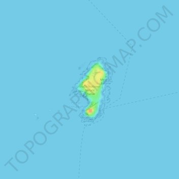
Name: Topografische Karte Staffa, Höhe, Relief.
Ort: Staffa, Argyll and Bute, Scotland, United Kingdom (56.43095 -6.34685 56.44050 -6.33676)
Durchschnittliche Höhe: 0 m
Minimale Höhe: -1 m
Maximale Höhe: 30 m
Andere topografische Karten
Klicken Sie auf eine Karte, um ihre Topografie, ihre Höhe und ihr Relief anzuzeigen.
Helensburgh
United Kingdom > Scotland > Argyll and Bute
Helensburgh, Argyll and Bute, Scotland, G84 7NY, United Kingdom
Durchschnittliche Höhe: 63 m
Fingal's Cave
United Kingdom > Scotland > Argyll and Bute
Fingal's Cave, Argyll and Bute, Scotland, United Kingdom
Durchschnittliche Höhe: 0 m
Garelochhead
United Kingdom > Scotland > Argyll and Bute
Garelochhead, Argyll and Bute, Scotland, G84 0AY, United Kingdom
Durchschnittliche Höhe: 110 m
North Connel
United Kingdom > Scotland > Argyll and Bute
North Connel, Argyll and Bute, Scotland, PA37 1PL, United Kingdom
Durchschnittliche Höhe: 19 m
Appin
United Kingdom > Scotland > Argyll and Bute
Appin, Argyll and Bute, Scotland, PA38 4DB, United Kingdom
Durchschnittliche Höhe: 93 m