
Topografische Karte Ebb and Flow
Klicken Sie auf die Karte, um die Höhe anzuzeigen.
Über diese Karte
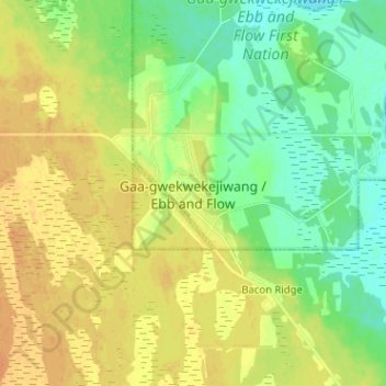
Name: Topografische Karte Ebb and Flow, Höhe, Relief.
Ort: Ebb and Flow, Manitoba, Canada (50.98522 -99.07438 51.06522 -98.99438)
Durchschnittliche Höhe: 261 m
Minimale Höhe: 246 m
Maximale Höhe: 275 m
Andere topografische Karten
Klicken Sie auf eine Karte, um ihre Topografie, ihre Höhe und ihr Relief anzuzeigen.
Winnipeg
Winnipeg lies at the bottom of the Red River Valley, a flood plain with an extremely flat topography. It is on the eastern edge of the Canadian Prairies in Western Canada and is known as the "Gateway to the West". Winnipeg is bordered by tallgrass prairie to the west and south and the aspen parkland to the…
Durchschnittliche Höhe: 236 m
Duck Mountain Provincial Park
Canada > Manitoba > Unorganized Division No. 20 (South)
Durchschnittliche Höhe: 656 m
Whiteshell Provincial Park
Canada > Manitoba > Unorganized Division No. 1
Durchschnittliche Höhe: 319 m
Riding Mountain National Park
The climate in the Riding Mountain region is similar to that of other regions of southwestern Manitoba. Under the Köppen classification it has a continental climate. It includes grasslands, upland boreal and eastern deciduous forest ecosystems. The park has hot summers and cold winters, with annual rainfall…
Durchschnittliche Höhe: 488 m
Paint Lake Provincial Park
Canada > Manitoba > Local Government District of Mystery Lake
Durchschnittliche Höhe: 198 m