
Spenden
Rüsten Sie sich für Ihr nächstes Abenteuer:
Als Amazon-Partner erhält diese Website eine Provision für qualifizierte Käufe, ohne zusätzliche Kosten für Sie.
Topografische Karte Modasa
Klicken Sie auf die Karte, um die Höhe anzuzeigen.
Spenden
Rüsten Sie sich für Ihr nächstes Abenteuer:
Als Amazon-Partner erhält diese Website eine Provision für qualifizierte Käufe, ohne zusätzliche Kosten für Sie.
Modasa
Modasa is located at 23°28′N 73°18′E / 23.47°N 73.3°E / 23.47; 73.3. It has an average elevation of 197 metres (646 feet). Most of the water for Modasa comes from the Mazum river, on which, about 5 kilometers from Modasa, the Mazum reservoir is situated.
Spenden
Rüsten Sie sich für Ihr nächstes Abenteuer:
Als Amazon-Partner erhält diese Website eine Provision für qualifizierte Käufe, ohne zusätzliche Kosten für Sie.
Über diese Karte
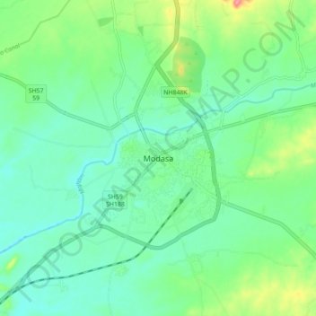
Name: Topografische Karte Modasa, Höhe, Relief.
Ort: Modasa, Modasa Taluka, Aravalli, Gujarat, 383315, India (23.42342 73.25906 23.50342 73.33906)
Durchschnittliche Höhe: 149 m
Minimale Höhe: 125 m
Maximale Höhe: 211 m
Spenden
Rüsten Sie sich für Ihr nächstes Abenteuer:
Als Amazon-Partner erhält diese Website eine Provision für qualifizierte Käufe, ohne zusätzliche Kosten für Sie.