
Topografische Karte Manning
Interaktive Karte
Klicken Sie auf die Karte, um die Höhe anzuzeigen.
Über diese Karte
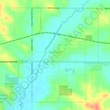
Name: Topografische Karte Manning, Höhe, Relief.
Ort: Manning, Carroll County, Iowa, United States (41.89571 -95.08538 41.92112 -95.04568)
Durchschnittliche Höhe: 415 m
Minimale Höhe: 398 m
Maximale Höhe: 448 m
Andere topografische Karten
Klicken Sie auf eine Karte, um ihre Topografie, ihre Höhe und ihr Relief anzuzeigen.
Willey
United States > Iowa > Carroll County
Willey, Carroll County, Iowa, United States
Durchschnittliche Höhe: 390 m
Templeton
United States > Iowa > Carroll County
Templeton, Carroll County, Iowa, United States
Durchschnittliche Höhe: 434 m
Middle Raccoon River
United States > Iowa > Carroll County > Carroll
Middle Raccoon River, Rolling Hills, Carroll, Carroll County, Iowa, 51401, United States
Durchschnittliche Höhe: 385 m
Ralston
United States > Iowa > Carroll County > Ralston
Ralston, Carroll County, Iowa, 51459, United States
Durchschnittliche Höhe: 342 m
Dedham
United States > Iowa > Carroll County
Dedham, Carroll County, Iowa, United States
Durchschnittliche Höhe: 395 m