
Topografische Karte River Amber
Interaktive Karte
Klicken Sie auf die Karte, um die Höhe anzuzeigen.
Über diese Karte
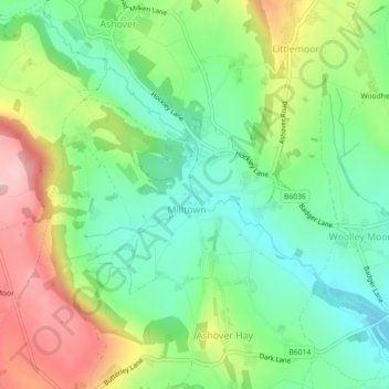
Name: Topografische Karte River Amber, Höhe, Relief.
Durchschnittliche Höhe: 194 m
Minimale Höhe: 117 m
Maximale Höhe: 319 m
Andere topografische Karten
Klicken Sie auf eine Karte, um ihre Topografie, ihre Höhe und ihr Relief anzuzeigen.
Killamarsh
United Kingdom > England > North East Derbyshire > Killamarsh
Killamarsh, North East Derbyshire, Derbyshire, East Midlands, England, S21 1DT, United Kingdom
Durchschnittliche Höhe: 92 m
Wessington
United Kingdom > England > North East Derbyshire > Wessington
Wessington, North East Derbyshire, Derbyshire, East Midlands, England, DE55 6EB, United Kingdom
Durchschnittliche Höhe: 149 m
Wingerworth
United Kingdom > England > North East Derbyshire > Wingerworth
Wingerworth, North East Derbyshire, Derbyshire, East Midlands, England, S42 6PR, United Kingdom
Durchschnittliche Höhe: 129 m
Spitewinter
United Kingdom > England > North East Derbyshire > Spitewinter
Spitewinter, Ashover CP, North East Derbyshire, Derbyshire, East Midlands, England, S45 0LH, United Kingdom
Durchschnittliche Höhe: 246 m
Old Tupton
United Kingdom > England > North East Derbyshire > Old Tupton
Old Tupton, North East Derbyshire, Derbyshire, East Midlands, England, S42 6LE, United Kingdom
Durchschnittliche Höhe: 131 m
Morton CP
United Kingdom > England > North East Derbyshire
Morton CP, North East Derbyshire, Derbyshire, East Midlands, England, United Kingdom
Durchschnittliche Höhe: 131 m
Stretton CP
United Kingdom > England > North East Derbyshire
Stretton CP, North East Derbyshire, Derbyshire, East Midlands, England, United Kingdom
Durchschnittliche Höhe: 140 m
Sutton cum Duckmanton CP
United Kingdom > England > North East Derbyshire
Sutton cum Duckmanton CP, North East Derbyshire, Derbyshire, East Midlands, England, United Kingdom
Durchschnittliche Höhe: 102 m