
Topografische Karte East River
Interaktive Karte
Klicken Sie auf die Karte, um die Höhe anzuzeigen.
Über diese Karte
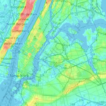
Name: Topografische Karte East River, Höhe, Relief.
Durchschnittliche Höhe: 15 m
Minimale Höhe: -10 m
Maximale Höhe: 100 m
Andere topografische Karten
Klicken Sie auf eine Karte, um ihre Topografie, ihre Höhe und ihr Relief anzuzeigen.
East Village
USA > New York > New York City
East Village, Manhattan, Manhattan Community Board 3, New York County, New York City, New York, USA
Durchschnittliche Höhe: 15 m
Meatpacking District
USA > New York > New York City
Meatpacking District, Manhattan, Manhattan Community Board 2, New York County, New York City, New York, 100014, USA
Durchschnittliche Höhe: 9 m
Governors Island
USA > New York > New York City
Governors Island, Manhattan Community Board 1, New York County, New York City, New York, USA
Durchschnittliche Höhe: 1 m
Chelsea
USA > New York > New York City
Chelsea, Manhattan, Manhattan Community Board 4, New York County, New York City, New York, USA
Durchschnittliche Höhe: 13 m
SoHo
USA > New York > New York City
SoHo, Manhattan, Manhattan Community Board 2, New York County, New York City, New York, 10012, USA
Durchschnittliche Höhe: 15 m
Barren Island
USA > New York > New York City
Barren Island, Kings County, New York City, New York, 11697, USA
Durchschnittliche Höhe: 16 m