
Topografische Karte Great Houghton
Interaktive Karte
Klicken Sie auf die Karte, um die Höhe anzuzeigen.
Über diese Karte
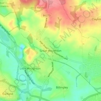
Name: Topografische Karte Great Houghton, Höhe, Relief.
Durchschnittliche Höhe: 54 m
Minimale Höhe: 13 m
Maximale Höhe: 112 m
Great Houghton is a village and civil parish in the Metropolitan Borough of Barnsley in South Yorkshire, England), on the border with West Yorkshire. It lies to the west of Thurnscoe, on the B6411 road, and is located at approximately 53° 33' 20" north, 1° 21' west, at an elevation of around 60 m above sea level. At the 2001 census it had a population of 2,261, increasing to 2,475 at the 2011 census.