
Topografische Karte Hoover Dam
Interaktive Karte
Klicken Sie auf die Karte, um die Höhe anzuzeigen.
Über diese Karte
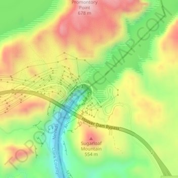
Name: Topografische Karte Hoover Dam, Höhe, Relief.
Ort: Hoover Dam, Mohave County, Arizona, United States (36.01474 -114.73939 36.01674 -114.73673)
Durchschnittliche Höhe: 429 m
Minimale Höhe: 197 m
Maximale Höhe: 682 m
The amount of electricity generated by Hoover Dam has been decreasing along with the falling water level in Lake Mead due to the prolonged drought in the 2010s and high demand for the Colorado River's water. Lake Mead fell to a new record low elevation of 1,071.61 feet (326.63 m) on July 1, 2016 before beginning to rebound slowly. Under its original design, the dam would no longer be able to generate power once the water level fell below 1,050 feet (320 m), which might have occurred in 2017 had water restrictions not been enforced. To lower the minimum power pool elevation from 1,050 to 950 feet (320 to 290 m), five wide-head turbines, designed to work efficiently with less flow, were installed. Due to the low water levels, by 2014 it was providing power only during periods of peak demand. Water levels were maintained at over 1,075 feet (328 m) in 2018 and 2019.
Andere topografische Karten
Klicken Sie auf eine Karte, um ihre Topografie, ihre Höhe und ihr Relief anzuzeigen.
New Kingman-Butler
United States > Arizona > Mohave County
New Kingman-Butler, Mohave County, Arizona, 86409, United States
Durchschnittliche Höhe: 1.037 m
Kingman
United States > Arizona > Mohave County
Kingman, Mohave County, Arizona, United States
Durchschnittliche Höhe: 1.131 m
Lake Havasu City
United States > Arizona > Mohave County
Lake Havasu City, Mohave County, Arizona, United States
Durchschnittliche Höhe: 317 m
Desert Hills
United States > Arizona > Mohave County
Desert Hills, Mohave County, Arizona, United States
Durchschnittliche Höhe: 182 m
Davis Dam
United States > Arizona > Mohave County > Bullhead City
Davis Dam, Bullhead City, Mohave County, Arizona, United States
Durchschnittliche Höhe: 216 m
Grand Canyon South Rim
United States > Arizona > Mohave County
Grand Canyon South Rim, Mohave County, Arizona, United States
Durchschnittliche Höhe: 1.082 m
Meadview
United States > Arizona > Mohave County > Meadview
Meadview, Mohave County, Arizona, United States
Durchschnittliche Höhe: 904 m
Kingman
United States > Arizona > Mohave County > Kingman
Kingman, Mohave County, Arizona, United States
Durchschnittliche Höhe: 1.135 m
Colorado Spring
United States > Arizona > Mohave County
Colorado Spring, 17 Mile Road, Mohave County, Arizona, United States
Durchschnittliche Höhe: 884 m
Bull Point
United States > Arizona > Mohave County
Bull Point, Mohave County, Arizona, United States
Durchschnittliche Höhe: 1.743 m
Bullhead City
United States > Arizona > Mohave County
Bullhead City, Mohave County, Arizona, United States
Durchschnittliche Höhe: 322 m
Peach Springs
United States > Arizona > Mohave County
Peach Springs, Mohave County, Arizona, 86434, United States
Durchschnittliche Höhe: 1.493 m