
Topografische Karte Elizabeth Metis Settlement
Interaktive Karte
Klicken Sie auf die Karte, um die Höhe anzuzeigen.
Über diese Karte
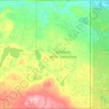
Name: Topografische Karte Elizabeth Metis Settlement, Höhe, Relief.
Durchschnittliche Höhe: 607 m
Minimale Höhe: 533 m
Maximale Höhe: 747 m
Andere topografische Karten
Klicken Sie auf eine Karte, um ihre Topografie, ihre Höhe und ihr Relief anzuzeigen.
Crane Lake
Canada > Alberta > Municipal District of Bonnyville > Happy Hollow
Crane Lake, Happy Hollow, Municipal District of Bonnyville, Alberta, Canada
Durchschnittliche Höhe: 562 m
Bourque Lake
Canada > Alberta > Municipal District of Bonnyville
Bourque Lake, Municipal District of Bonnyville, Alberta, Canada
Durchschnittliche Höhe: 617 m
Hilda Lake
Canada > Alberta > Municipal District of Bonnyville
Hilda Lake, Municipal District of Bonnyville, Alberta, Canada
Durchschnittliche Höhe: 555 m