
Topografische Karte South Kootenay Pass
Interaktive Karte
Klicken Sie auf die Karte, um die Höhe anzuzeigen.
Über diese Karte
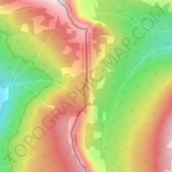
Name: Topografische Karte South Kootenay Pass, Höhe, Relief.
Durchschnittliche Höhe: 2.007 m
Minimale Höhe: 1.658 m
Maximale Höhe: 2.321 m
Andere topografische Karten
Klicken Sie auf eine Karte, um ihre Topografie, ihre Höhe und ihr Relief anzuzeigen.
Canmore
Canada > Alberta > Division No. 15
Canmore, Division No. 15, Alberta, T1W 2H4, Canada
Durchschnittliche Höhe: 1.565 m
High River
Canada > Alberta > Town of High River
High River, Town of High River, Alberta, T1V 1R6, Canada
Durchschnittliche Höhe: 1.042 m
Pyramid Mountain
Canada > Alberta > Division No. 15 > Municipality of Jasper
Pyramid Mountain, Municipality of Jasper, Division No. 15, Alberta, Canada
Durchschnittliche Höhe: 2.152 m
Parc national de Banff
Parc national de Banff, Alberta, Canada
Durchschnittliche Höhe: 1.848 m
Saskatchewan River Crossing
Canada > Alberta > Improvement District No. 9
Saskatchewan River Crossing, Improvement District No. 9, Alberta, Canada
Durchschnittliche Höhe: 1.443 m
Improvement District No. 9
Improvement District No. 9, Alberta, Canada
Durchschnittliche Höhe: 1.848 m
Hamlet of Monarch
Canada > Alberta > Lethbridge County
Hamlet of Monarch, Lethbridge County, Alberta, Canada
Durchschnittliche Höhe: 933 m
Brule Lake
Canada > Alberta > Yellowhead County > Brûlé
Brule Lake, Brûlé, Yellowhead County, Alberta, Canada
Durchschnittliche Höhe: 1.250 m
Vanrena
Canada > Alberta > Municipal District of Fairview
Vanrena, Municipal District of Fairview, Alberta, Canada
Durchschnittliche Höhe: 601 m
Mount Henday
Canada > Alberta > Improvement District No. 12
Mount Henday, Improvement District No. 12, Alberta, Canada
Durchschnittliche Höhe: 2.334 m
La Crete
Canada > Alberta > Mackenzie County
La Crete, Mackenzie County, Alberta, T0H 2H0, Canada
Durchschnittliche Höhe: 323 m
Cairngorm
Canada > Alberta > Municipality of Jasper
Cairngorm, Municipality of Jasper, Alberta, Canada
Durchschnittliche Höhe: 2.240 m
Cochrane
Canada > Alberta > Town of Cochrane > Cochrane
Cochrane, Town of Cochrane, Alberta, T4V 2A7, Canada
Durchschnittliche Höhe: 1.205 m
Prince's Island Park
Prince's Island Park, Eau Claire, Calgary, Alberta, T2P 0R1, Canada
Durchschnittliche Höhe: 1.065 m
City of Red Deer
Canada > Alberta > Division No. 8
City of Red Deer, Division No. 8, Alberta, Canada
Durchschnittliche Höhe: 890 m
Summer Village of Yellowstone
Canada > Alberta > Yellowstone (summer village) > Summer Village of Yellowstone
Summer Village of Yellowstone, Yellowstone (summer village), Alberta, Canada
Durchschnittliche Höhe: 733 m
Millet
Canada > Alberta > Town of Millet > Millet
Millet, Town of Millet, Alberta, T0C 1Z0, Canada
Durchschnittliche Höhe: 765 m
Crowsnest Pass (municipality)
Crowsnest Pass (municipality), Alberta, T0K 0M0, Canada
Durchschnittliche Höhe: 1.537 m
Grande Prairie
Canada > Alberta > Division No. 19
Grande Prairie, Division No. 19, Alberta, Canada
Durchschnittliche Höhe: 665 m
Comté de Strathcona
Canada > Alberta > Comté de Strathcona
Comté de Strathcona, Alberta, Canada
Durchschnittliche Höhe: 691 m
Town of Picture Butte
Town of Picture Butte, Alberta, T0K 1V0, Canada
Durchschnittliche Höhe: 905 m
Lake Louise
Canada > Alberta > Division No. 15
Lake Louise, Division No. 15, Alberta, Canada
Durchschnittliche Höhe: 1.617 m
Town of Pincher Creek
Town of Pincher Creek, Alberta, T0K 1W0, Canada
Durchschnittliche Höhe: 1.149 m
Avonmore
Canada > Alberta > Division No. 11
Avonmore, Mill Creek South, Division No. 11, Alberta, T6C 2N1, Canada
Durchschnittliche Höhe: 673 m
Medicine Hat
Canada > Alberta > Medicine Hat
Medicine Hat, Medicine Hat (city), Alberta, Canada
Durchschnittliche Höhe: 708 m
McLennan (town)
McLennan (town), Alberta, T0H 2L0, Canada
Durchschnittliche Höhe: 640 m
Drumheller (town)
Drumheller (town), Alberta, T0J 2V0, Canada
Durchschnittliche Höhe: 855 m
Kananaskis Improvement District
Kananaskis Improvement District, Alberta, Canada
Durchschnittliche Höhe: 1.740 m