
Topografische Karte Le Bois Josselin
Interaktive Karte
Klicken Sie auf die Karte, um die Höhe anzuzeigen.
Über diese Karte
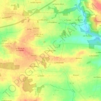
Name: Topografische Karte Le Bois Josselin, Höhe, Relief.
Durchschnittliche Höhe: 88 m
Minimale Höhe: 56 m
Maximale Höhe: 110 m
Andere topografische Karten
Klicken Sie auf eine Karte, um ihre Topografie, ihre Höhe und ihr Relief anzuzeigen.
La Grange Neuve
France > Bretagne > Morbihan > Ploërmel
La Grange Neuve, Ploërmel, Pontivy, Morbihan, Bretagne, France métropolitaine, 56800, France
Durchschnittliche Höhe: 73 m
Le Clos Hazel
France > Bretagne > Morbihan > Ploërmel
Le Clos Hazel, Ploërmel, Pontivy, Morbihan, Bretagne, France métropolitaine, 56800, France
Durchschnittliche Höhe: 59 m
La Croix aux Loups
France > Bretagne > Morbihan > Ploërmel
La Croix aux Loups, Ploërmel, Pontivy, Morbihan, Bretagne, France métropolitaine, 56800, France
Durchschnittliche Höhe: 58 m
Le Champ des Oiseaux
France > Bretagne > Morbihan > Ploërmel
Le Champ des Oiseaux, Ploërmel, Pontivy, Morbihan, Bretagne, France métropolitaine, 56800, France
Durchschnittliche Höhe: 56 m