
Topografische Karte Alabama River
Interaktive Karte
Klicken Sie auf die Karte, um die Höhe anzuzeigen.
Über diese Karte
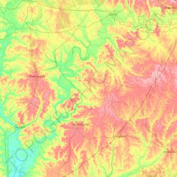
Name: Topografische Karte Alabama River, Höhe, Relief.
Ort: Alabama River, Alabama, United States (31.13551 -87.94413 32.49049 -86.27818)
Durchschnittliche Höhe: 68 m
Minimale Höhe: 0 m
Maximale Höhe: 175 m
Andere topografische Karten
Klicken Sie auf eine Karte, um ihre Topografie, ihre Höhe und ihr Relief anzuzeigen.
Millport
United States > Alabama > Lamar County
Millport, Lamar County, Alabama, United States
Durchschnittliche Höhe: 94 m
Selma
United States > Alabama > Dallas County
Selma, Dallas County, Alabama, 36701, United States
Durchschnittliche Höhe: 40 m
Mobile
United States > Alabama > Mobile County > Mobile
Mobile, Mobile County, Alabama, United States
Durchschnittliche Höhe: 14 m
Red Bay
United States > Alabama > Franklin County > Red Bay
Red Bay, Franklin County, Alabama, 35582, United States
Durchschnittliche Höhe: 177 m
Madison County
United States > Alabama > Madison County
Madison County, Alabama, United States
Durchschnittliche Höhe: 245 m
Mount Brandon
Mount Brandon, DeKalb County, Alabama, United States
Durchschnittliche Höhe: 419 m
Montgomery
United States > Alabama > Montgomery County
Montgomery, Montgomery County, Alabama, United States
Durchschnittliche Höhe: 64 m