
Vielen Dank für die Unterstützung dieser Website ❤️
Spenden
Spenden
Rüsten Sie sich für Ihr nächstes Abenteuer:
Als Amazon-Partner erhält diese Website eine Provision für qualifizierte Käufe, ohne zusätzliche Kosten für Sie.
Topografische Karte Barangay 3
Klicken Sie auf die Karte, um die Höhe anzuzeigen.
Vielen Dank für die Unterstützung dieser Website ❤️
Spenden
Spenden
Rüsten Sie sich für Ihr nächstes Abenteuer:
Als Amazon-Partner erhält diese Website eine Provision für qualifizierte Käufe, ohne zusätzliche Kosten für Sie.
Über diese Karte
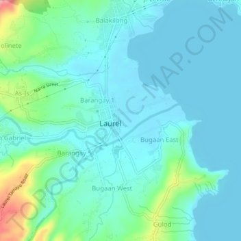
Name: Topografische Karte Barangay 3, Höhe, Relief.
Ort: Barangay 3, Laurel, Batangas, Calabarzon, 4221, Philippines (14.03090 120.91498 14.07090 120.95498)
Durchschnittliche Höhe: 33 m
Minimale Höhe: 4 m
Maximale Höhe: 167 m
Vielen Dank für die Unterstützung dieser Website ❤️
Spenden
Spenden
Rüsten Sie sich für Ihr nächstes Abenteuer:
Als Amazon-Partner erhält diese Website eine Provision für qualifizierte Käufe, ohne zusätzliche Kosten für Sie.