
Topografische Karte Patan
Interaktive Karte
Klicken Sie auf die Karte, um die Höhe anzuzeigen.
Über diese Karte
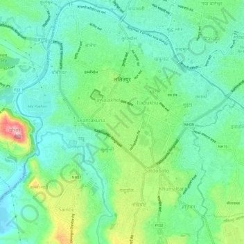
Name: Topografische Karte Patan, Höhe, Relief.
Durchschnittliche Höhe: 1.312 m
Minimale Höhe: 1.263 m
Maximale Höhe: 1.431 m
Lalitpur Metropolitan City (Sanskrit: पाटन Pāṭana, Nepal bhasa. 𑐫𑐮 Yela, ) is a Metropolitan city and fourth most populous city of Nepal with 299,843 inhabitants living in 49,044 households per 2021 cencus. It is located in the south-central part of Kathmandu Valley, a large valley in the high plateaus in central Nepal, at an altitude of 1,400 metres (4,600 feet).
Andere topografische Karten
Klicken Sie auf eine Karte, um ihre Topografie, ihre Höhe und ihr Relief anzuzeigen.