
Topografische Karte Monticello
Interaktive Karte
Klicken Sie auf die Karte, um die Höhe anzuzeigen.
Über diese Karte
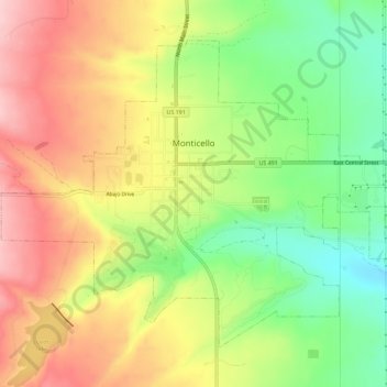
Name: Topografische Karte Monticello, Höhe, Relief.
Ort: Monticello, San Juan County, Utah, United States (37.85117 -109.36881 37.88708 -109.31155)
Durchschnittliche Höhe: 2.145 m
Minimale Höhe: 2.049 m
Maximale Höhe: 2.240 m
Monticello is located at the base of the Abajo Mountains, or the Blue Mountains, which are part of the Manti-La Sal National Forest. The elevation of Monticello is 7,069 feet (2,155 m). From Monticello, a tree formation on the Blue Mountains can be seen, which resembles a horse's head and neck, which can be seen from any point in town.
Andere topografische Karten
Klicken Sie auf eine Karte, um ihre Topografie, ihre Höhe und ihr Relief anzuzeigen.
Allen Canyon
United States > Utah > San Juan County
Allen Canyon, San Juan County, Utah, United States
Durchschnittliche Höhe: 1.950 m
Lake Powell
United States > Utah > San Juan County
Lake Powell, San Juan County, Utah, United States
Durchschnittliche Höhe: 1.555 m
White Canyon
United States > Utah > San Juan County
White Canyon, San Juan County, Utah, United States
Durchschnittliche Höhe: 1.841 m
Beef Basin Wash
United States > Utah > San Juan County
Beef Basin Wash, San Juan County, Utah, United States
Durchschnittliche Höhe: 2.088 m
Spanish Valley
United States > Utah > San Juan County
Spanish Valley, San Juan County, Utah, United States
Durchschnittliche Höhe: 1.708 m
Rainbow Bridge National Monument
United States > Utah > San Juan County
Rainbow Bridge National Monument, San Juan County, Utah, United States
Durchschnittliche Höhe: 1.288 m
Hovenweep National Monument
United States > Utah > San Juan County
Hovenweep National Monument, Shiprock Agency, San Juan County, Utah, United States
Durchschnittliche Höhe: 1.632 m
Red Canyon
United States > Utah > San Juan County
Red Canyon, San Juan County, Utah, United States
Durchschnittliche Höhe: 1.479 m
Abajo Mountains
United States > Utah > San Juan County
Abajo Mountains, San Juan County, Utah, United States
Durchschnittliche Höhe: 2.874 m
Island in the Sky
United States > Utah > San Juan County
Island in the Sky, San Juan County, Utah, United States
Durchschnittliche Höhe: 1.804 m
Mexican Hat
United States > Utah > San Juan County
Mexican Hat, San Juan County, Utah, United States
Durchschnittliche Höhe: 1.346 m
Blanding
United States > Utah > San Juan County
Blanding, San Juan County, Utah, 84511, United States
Durchschnittliche Höhe: 1.851 m
Kane Gulch
United States > Utah > San Juan County
Kane Gulch, San Juan County, Utah, United States
Durchschnittliche Höhe: 1.975 m
Fish Creek Canyon Wilderness Study Area
United States > Utah > San Juan County
Fish Creek Canyon Wilderness Study Area, San Juan County, Utah, United States
Durchschnittliche Höhe: 1.817 m
Colorado Plateau
United States > Utah > San Juan County
Colorado Plateau, Western Navajo Agency, San Juan County, Utah, United States
Durchschnittliche Höhe: 1.512 m
Bullet Canyon
United States > Utah > San Juan County
Bullet Canyon, San Juan County, Utah, United States
Durchschnittliche Höhe: 1.893 m
La Sal
United States > Utah > San Juan County
La Sal, San Juan County, Utah, 84530, United States
Durchschnittliche Höhe: 2.098 m
Bluff
United States > Utah > San Juan County > Bluff
Bluff, San Juan County, Utah, 84512, United States
Durchschnittliche Höhe: 1.424 m
Oljato-Monument Valley
United States > Utah > San Juan County
Oljato-Monument Valley, San Juan County, Utah, 84536, United States
Durchschnittliche Höhe: 1.557 m
Upheaval Dome
United States > Utah > San Juan County
Upheaval Dome, San Juan County, Utah, United States
Durchschnittliche Höhe: 1.627 m
Stagecoach
United States > Utah > San Juan County
Stagecoach, San Juan County, Utah, United States
Durchschnittliche Höhe: 1.690 m