
Topografische Karte Homyel
Interaktive Karte
Klicken Sie auf die Karte, um die Höhe anzuzeigen.
Über diese Karte
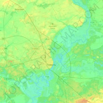
Name: Topografische Karte Homyel, Höhe, Relief.
Ort: Homyel, Homyel Region, Belarus (52.34327 30.74695 52.57076 31.17153)
Durchschnittliche Höhe: 130 m
Minimale Höhe: 109 m
Maximale Höhe: 186 m
The terrain on which the city as a whole is built, is flat. On the right bank of the river, it is a gradually decreasing plain water-glacial and fluvial terrace of the Sozh river. The left bank is a low-lying alluvial plain. The highest elevation of 144 meters above sea level is found at the northern outskirts of Gomel, the lowest elevation of 115 m at the water boundary Sozh river. Novobelitskiy district, which is located on the left bank of the river (i.e., towards the south), has elevations averaging of 10–15 meters lower than the northern and central parts of the city.
Andere topografische Karten
Klicken Sie auf eine Karte, um ihre Topografie, ihre Höhe und ihr Relief anzuzeigen.
Karani
Belarus > Homyel Region > Svietlahorsk District > Давыдаўскі сельскі Савет
Karani, Давыдаўскі сельскі Савет, Svietlahorsk District, Homyel Region, Belarus
Durchschnittliche Höhe: 135 m