
Topografische Karte Tipner
Interaktive Karte
Klicken Sie auf die Karte, um die Höhe anzuzeigen.
Über diese Karte
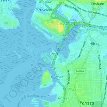
Name: Topografische Karte Tipner, Höhe, Relief.
Ort: Tipner, Portsmouth, England, PO2 8RD, United Kingdom (50.80673 -1.11263 50.84673 -1.07263)
Durchschnittliche Höhe: 3 m
Minimale Höhe: -4 m
Maximale Höhe: 18 m
Andere topografische Karten
Klicken Sie auf eine Karte, um ihre Topografie, ihre Höhe und ihr Relief anzuzeigen.
Portsea Island
United Kingdom > England > Portsmouth
Portsea Island, Portsmouth, England, United Kingdom
Durchschnittliche Höhe: 3 m
Portsdown Hill
United Kingdom > England > Portsmouth
Portsdown Hill, Portsdown Hill Road, Wymering, Cosham, Portsmouth, South East, England, PO6 3LS, United Kingdom
Durchschnittliche Höhe: 39 m
Bastion 3, Hilsea Lines
United Kingdom > England > Portsmouth
Bastion 3, Hilsea Lines, Scott Road, Hilsea, Portsmouth, England, PO3 5LX, United Kingdom
Durchschnittliche Höhe: 4 m
Gobs Barrow
United Kingdom > England > Portsmouth
Gobs Barrow, Portsdown Hill Road, Drayton, Portsmouth, South East England, England, PO6 1BG, United Kingdom
Durchschnittliche Höhe: 40 m
Hilsea Lines
United Kingdom > England > Portsmouth > Tipner
Hilsea Lines, Hilsea Crescent, Hilsea, Tipner, Portsmouth, South East, England, PO2 9SN, United Kingdom
Durchschnittliche Höhe: 5 m
Victoria Park
United Kingdom > England > Portsmouth
Victoria Park, Stamshaw, Portsea, Portsmouth, South East, England, PO1 3HJ, United Kingdom
Durchschnittliche Höhe: 4 m
Fort Cumberland
United Kingdom > England > Portsmouth
Fort Cumberland, Portsmouth, South East, England, PO4 9LD, United Kingdom
Durchschnittliche Höhe: 1 m