
Topografische Karte Moraine Lake
Interaktive Karte
Klicken Sie auf die Karte, um die Höhe anzuzeigen.
Über diese Karte
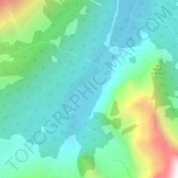
Name: Topografische Karte Moraine Lake, Höhe, Relief.
Ort: Moraine Lake, Division No. 15, Alberta, Canada (51.31569 -116.19126 51.32768 -116.17854)
Durchschnittliche Höhe: 2.101 m
Minimale Höhe: 1.825 m
Maximale Höhe: 2.979 m
Moraine Lake is a glacially fed lake in Banff National Park, 14 kilometres (8.7 mi) outside the hamlet of Lake Louise, Alberta, Canada. It is situated in the Valley of the Ten Peaks, at an elevation of approximately 1,884 metres (6,181 ft). The lake has a surface area of 50 hectares (120 acres).
Andere topografische Karten
Klicken Sie auf eine Karte, um ihre Topografie, ihre Höhe und ihr Relief anzuzeigen.
Banff National Park
Canada > Alberta > Division No. 15
Banff National Park, Division No. 15, Alberta, Canada
Durchschnittliche Höhe: 1.848 m
Jasper National Park
Canada > Alberta > Division No. 15
Jasper National Park, Division No. 15, Alberta, Canada
Durchschnittliche Höhe: 1.782 m
Toronto Peak
Canada > Alberta > Division No. 15
Toronto Peak, Division No. 15, Alberta, Canada
Durchschnittliche Höhe: 2.423 m
Lake Louise
Canada > Alberta > Division No. 15
Lake Louise, Division No. 15, Alberta, Canada
Durchschnittliche Höhe: 1.617 m