
Topografische Karte Municipal Unit of Ano Liosia
Interaktive Karte
Klicken Sie auf die Karte, um die Höhe anzuzeigen.
Über diese Karte
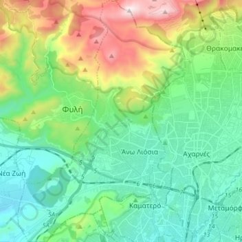
Name: Topografische Karte Municipal Unit of Ano Liosia, Höhe, Relief.
Durchschnittliche Höhe: 356 m
Minimale Höhe: 50 m
Maximale Höhe: 1.163 m
Andere topografische Karten
Klicken Sie auf eine Karte, um ihre Topografie, ihre Höhe und ihr Relief anzuzeigen.
Vilia
Greece > Attica > Regional Unit of West Attica > Municipal Unit of Vilia
Vilia, Municipal Unit of Vilia, Municipality of Mandra-Eidyllia, Regional Unit of West Attica, Attica, 190 12, Greece
Durchschnittliche Höhe: 604 m
Aspropyrgos
Greece > Attica > Regional Unit of West Attica
Aspropyrgos, Municipality of Aspropyrgos, Regional Unit of West Attica, Attica, 193 00, Greece
Durchschnittliche Höhe: 53 m
Psatha
Greece > Attica > Regional Unit of West Attica > Municipal Unit of Vilia > Psatha
Psatha, Community of Vilia, Municipal Unit of Vilia, Municipality of Mandra-Eidyllia, Regional Unit of West Attica, Attica, 190 12, Greece
Durchschnittliche Höhe: 79 m
Eleusis
Greece > Attica > Regional Unit of West Attica > Municipal Unit of Elefsina
Eleusis, Municipal Unit of Elefsina, Municipality of Elefsina, Regional Unit of West Attica, Attica, 192 00, Greece
Durchschnittliche Höhe: 30 m