
Topografische Karte Andrate
Interaktive Karte
Klicken Sie auf die Karte, um die Höhe anzuzeigen.
Über diese Karte
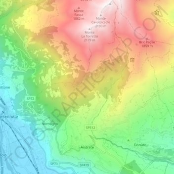
Name: Topografische Karte Andrate, Höhe, Relief.
Ort: Andrate, Provincia di Torino, Piemont, Italy (45.51721 7.86630 45.58222 7.90240)
Durchschnittliche Höhe: 1.059 m
Minimale Höhe: 249 m
Maximale Höhe: 2.220 m
Andrate borders the following municipalities: Settimo Vittone, Donato, Nomaglio, Borgofranco d'Ivrea, and Chiaverano. It is located at the top of the Moraine of Ivrea, with elevations ranging from 550 to 2,227 meters above the sea level.