
Topografische Karte Cooper Marsh Conservation Area
Interaktive Karte
Klicken Sie auf die Karte, um die Höhe anzuzeigen.
Über diese Karte
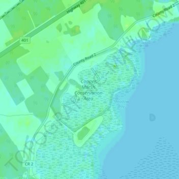
Name: Topografische Karte Cooper Marsh Conservation Area, Höhe, Relief.
Durchschnittliche Höhe: 48 m
Minimale Höhe: 44 m
Maximale Höhe: 54 m
Andere topografische Karten
Klicken Sie auf eine Karte, um ihre Topografie, ihre Höhe und ihr Relief anzuzeigen.
Glen Walter
Canada > Ontario > South Glengarry > Glen Walter
Glen Walter, South Glengarry, Stormont, Dundas and Glengarry Counties, Eastern Ontario, Ontario, K6H 5R5, Canada
Durchschnittliche Höhe: 50 m
Raisin River
Canada > Ontario > South Glengarry
Raisin River, South Glengarry, Stormont, Dundas and Glengarry Counties, Eastern Ontario, Ontario, K0C 2A0, Canada
Durchschnittliche Höhe: 73 m
Rivière Beaudette
Canada > Ontario > South Glengarry
Rivière Beaudette, South Glengarry, Stormont, Dundas and Glengarry Counties, Ontario, K0C 1L0, Canada
Durchschnittliche Höhe: 69 m