
Topografische Karte Bayard
Interaktive Karte
Klicken Sie auf die Karte, um die Höhe anzuzeigen.
Über diese Karte
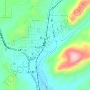
Name: Topografische Karte Bayard, Höhe, Relief.
Ort: Bayard, Grant County, New Mexico, 88023, United States (32.75026 -108.14493 32.76880 -108.11978)
Durchschnittliche Höhe: 1.816 m
Minimale Höhe: 1.746 m
Maximale Höhe: 2.003 m
Bayard is located in the southern foothills of the Pinos Altos Range and Mogollon Mountains in the southwestern portion of New Mexico and situated east of the Continental Divide at an elevation of approximately 5,800 feet (1,800 m). Gila National Forest lies north from here. A semi-arid desert of predominantly grasses and yucca is in Bayard's southern portion.
Andere topografische Karten
Klicken Sie auf eine Karte, um ihre Topografie, ihre Höhe und ihr Relief anzuzeigen.
Silver City
United States > New Mexico > Grant County
Silver City, Grant County, New Mexico, 88062, United States
Durchschnittliche Höhe: 1.850 m
Hurley
United States > New Mexico > Grant County
Hurley, Grant County, New Mexico, United States
Durchschnittliche Höhe: 1.734 m
Arenas Valley
United States > New Mexico > Grant County > Silver City
Arenas Valley, Silver City, Grant County, New Mexico, 88022, United States
Durchschnittliche Höhe: 1.873 m
Santa Clara
United States > New Mexico > Grant County
Santa Clara, Grant County, New Mexico, 88026, United States
Durchschnittliche Höhe: 1.833 m
Mallet Pond
United States > New Mexico > Grant County
Mallet Pond, Grant County, New Mexico, United States
Durchschnittliche Höhe: 1.802 m
Dwyer
United States > New Mexico > Grant County
Dwyer, Grant County, New Mexico, 88034, United States
Durchschnittliche Höhe: 1.616 m
Pinos Altos
United States > New Mexico > Grant County
Pinos Altos, Grant County, New Mexico, 88053, United States
Durchschnittliche Höhe: 2.142 m
Aldo Leopold Wilderness
United States > New Mexico > Grant County
Aldo Leopold Wilderness, Grant County, New Mexico, United States
Durchschnittliche Höhe: 2.249 m