
Spenden
Rüsten Sie sich für Ihr nächstes Abenteuer:
Als Amazon-Partner erhält diese Website eine Provision für qualifizierte Käufe, ohne zusätzliche Kosten für Sie.
Topografische Karte Ashland
Klicken Sie auf die Karte, um die Höhe anzuzeigen.
Spenden
Rüsten Sie sich für Ihr nächstes Abenteuer:
Als Amazon-Partner erhält diese Website eine Provision für qualifizierte Käufe, ohne zusätzliche Kosten für Sie.
Ashland
According to the United States Census Bureau, the CDP has a total area of 1.8 square miles (4.7 km2), all of it land and sits at an elevation of 43 feet above sea level.
Spenden
Rüsten Sie sich für Ihr nächstes Abenteuer:
Als Amazon-Partner erhält diese Website eine Provision für qualifizierte Käufe, ohne zusätzliche Kosten für Sie.
Über diese Karte
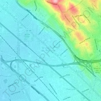
Name: Topografische Karte Ashland, Höhe, Relief.
Ort: Ashland, Alameda County, California, 94580, United States (37.67465 -122.13385 37.71465 -122.09385)
Durchschnittliche Höhe: 38 m
Minimale Höhe: 3 m
Maximale Höhe: 185 m
Spenden
Rüsten Sie sich für Ihr nächstes Abenteuer:
Als Amazon-Partner erhält diese Website eine Provision für qualifizierte Käufe, ohne zusätzliche Kosten für Sie.
Andere topografische Karten
Klicken Sie auf eine Karte, um ihre Topografie, ihre Höhe und ihr Relief anzuzeigen.
Quarry Lakes Regional Park
United States > California > Alameda County > Fremont > Eberly
Durchschnittliche Höhe: 17 m
Reinhardt-Redwood Regional Park
United States > California > Alameda County > Oakland
Durchschnittliche Höhe: 292 m
Spenden
Rüsten Sie sich für Ihr nächstes Abenteuer:
Als Amazon-Partner erhält diese Website eine Provision für qualifizierte Käufe, ohne zusätzliche Kosten für Sie.
Horseshoe Lake
United States > California > Alameda County > Fremont > Eberly
Durchschnittliche Höhe: 23 m
John F Kennedy Park
United States > California > Alameda County > Hayward
Durchschnittliche Höhe: 11 m
Oakland Casting Club pools
United States > California > Alameda County > Oakland
Durchschnittliche Höhe: 158 m
Spenden
Rüsten Sie sich für Ihr nächstes Abenteuer:
Als Amazon-Partner erhält diese Website eine Provision für qualifizierte Käufe, ohne zusätzliche Kosten für Sie.
Dougherty Hills Open Space
United States > California > Alameda County > Dublin > Komandorski Village
Durchschnittliche Höhe: 120 m
Garin Regional Park
United States > California > Alameda County > Hayward
Durchschnittliche Höhe: 206 m
Lake Del Valle
United States > California > Alameda County
The dam is 230 feet (70 m) high and 880 feet (270 m) long. Its crest elevation is 773 feet (236 m). The dam contains 4,150,000 cubic yards (3,170,000 m3) of earth fill.
Durchschnittliche Höhe: 339 m
Spenden
Rüsten Sie sich für Ihr nächstes Abenteuer:
Als Amazon-Partner erhält diese Website eine Provision für qualifizierte Käufe, ohne zusätzliche Kosten für Sie.