Topografische Karte Uthind
Interaktive Karte
Klicken Sie auf die Karte, um die Höhe anzuzeigen.
Über diese Karte
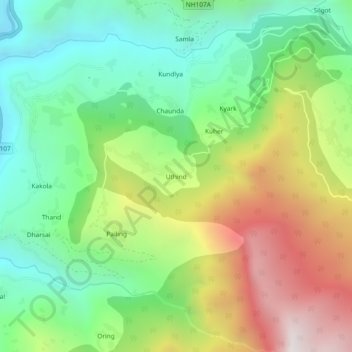
Name: Topografische Karte Uthind, Höhe, Relief.
Ort: Uthind, Ukhimath, Rudraprayag, Uttarakhand, 246419, India (30.45730 79.08898 30.49730 79.12898)
Durchschnittliche Höhe: 1.601 m
Minimale Höhe: 967 m
Maximale Höhe: 2.633 m
Andere topografische Karten
Klicken Sie auf eine Karte, um ihre Topografie, ihre Höhe und ihr Relief anzuzeigen.
Dilmi
India > Uttarakhand > Ukhimath > Sari
Dilmi, Sari, Ukhimath, Rudraprayag District, Uttarakhand, 246469, India
Durchschnittliche Höhe: 1.898 m
Kedarnath
India > Uttarakhand > Ukhimath
Kedarnath, Ukhimath, Rudraprayag District, Uttarakhand, India
Durchschnittliche Höhe: 4.219 m
Gaurikund
India > Uttarakhand > Ukhimath
Gaurikund, Ukhimath, Rudraprayag, Uttarakhand, India
Durchschnittliche Höhe: 2.589 m
Sitapur
India > Uttarakhand > Ukhimath > Sitapur
Sitapur, Ukhimath, Rudraprayag, Uttarakhand, 246471, India
Durchschnittliche Höhe: 2.062 m
Budha Madmaheshwar
India > Uttarakhand > Ukhimath > Budha Madmaheshwar
Budha Madmaheshwar, Ukhimath, Rudraprayag, Uttarakhand, India
Durchschnittliche Höhe: 3.045 m
Sonprayag
India > Uttarakhand > Ukhimath > Sonprayag
Sonprayag, Ukhimath, Rudraprayag, Uttarakhand, 246471, India
Durchschnittliche Höhe: 2.053 m
Madmaheshwar
India > Uttarakhand > Ukhimath > Madmaheshwar
Madmaheshwar, Ukhimath, Rudraprayag, Uttarakhand, India
Durchschnittliche Höhe: 3.160 m
Chopta Chatti
India > Uttarakhand > Ukhimath > Chopta Chatti
Chopta Chatti, Ukhimath, Rudraprayag, Uttarakhand, India
Durchschnittliche Höhe: 2.759 m
Rānsi
India > Uttarakhand > Ukhimath > Rānsi
Rānsi, Ukhimath, Rudraprayag, Uttarakhand, India
Durchschnittliche Höhe: 2.054 m