
Topografische Karte Muscoda
Interaktive Karte
Klicken Sie auf die Karte, um die Höhe anzuzeigen.
Über diese Karte
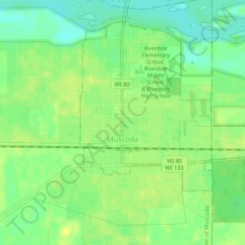
Name: Topografische Karte Muscoda, Höhe, Relief.
Ort: Muscoda, Grant County, Wisconsin, United States (43.17606 -90.44947 43.19829 -90.41269)
Durchschnittliche Höhe: 210 m
Minimale Höhe: 199 m
Maximale Höhe: 217 m
Andere topografische Karten
Klicken Sie auf eine Karte, um ihre Topografie, ihre Höhe und ihr Relief anzuzeigen.
Town of Glen Haven
United States > Wisconsin > Grant County
Town of Glen Haven, Grant County, Wisconsin, 53810, United States
Durchschnittliche Höhe: 262 m
Cassville
United States > Wisconsin > Grant County
Cassville, Grant County, Wisconsin, United States
Durchschnittliche Höhe: 222 m
Town of Beetown
United States > Wisconsin > Grant County
Town of Beetown, Grant County, Wisconsin, 53802, United States
Durchschnittliche Höhe: 281 m
Blue River
United States > Wisconsin > Grant County
Blue River, Grant County, Wisconsin, United States
Durchschnittliche Höhe: 223 m