
Spenden
Rüsten Sie sich für Ihr nächstes Abenteuer:
Als Amazon-Partner erhält diese Website eine Provision für qualifizierte Käufe, ohne zusätzliche Kosten für Sie.
Topografische Karte Colonia Fabricii
Klicken Sie auf die Karte, um die Höhe anzuzeigen.
Spenden
Rüsten Sie sich für Ihr nächstes Abenteuer:
Als Amazon-Partner erhält diese Website eine Provision für qualifizierte Käufe, ohne zusätzliche Kosten für Sie.
Über diese Karte
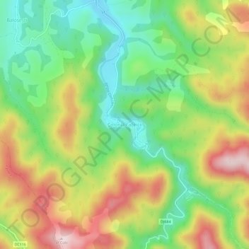
Name: Topografische Karte Colonia Fabricii, Höhe, Relief.
Ort: Colonia Fabricii, Tomești, Timiș, 307412, Romania (45.74553 22.29452 45.78553 22.33452)
Durchschnittliche Höhe: 405 m
Minimale Höhe: 235 m
Maximale Höhe: 629 m
Spenden
Rüsten Sie sich für Ihr nächstes Abenteuer:
Als Amazon-Partner erhält diese Website eine Provision für qualifizierte Käufe, ohne zusätzliche Kosten für Sie.
Andere topografische Karten
Klicken Sie auf eine Karte, um ihre Topografie, ihre Höhe und ihr Relief anzuzeigen.
Timișoara
Timișoara lies at an altitude of 90 metres on the southeast edge of the Banat Plain, part of the Pannonian Plain, near the divergence of the Timiș and Bega rivers. The waters of the two rivers form a swampy and frequently flooded land. Timișoara developed on one of few places where the swamps could be…
Durchschnittliche Höhe: 92 m
Sannicolau Mare
The territory is located in the Mureș Plain, which is a typical form of fluvio-lacustrine subsidence, with shallow valleys with abandoned riverbeds resulting from the regularization of watercourses and drainage, with an altitude between 80–85 m (262–279 ft). The northern part is located in the former…
Durchschnittliche Höhe: 85 m
Spenden
Rüsten Sie sich für Ihr nächstes Abenteuer:
Als Amazon-Partner erhält diese Website eine Provision für qualifizierte Käufe, ohne zusätzliche Kosten für Sie.
Timișoara
Timișoara lies at an altitude of 90 metres on the southeast edge of the Banat Plain, part of the Pannonian Plain, near the divergence of the Timiș and Bega rivers. The waters of the two rivers form a swampy and frequently flooded land. Timișoara developed on one of few places where the swamps could be…
Durchschnittliche Höhe: 92 m
Spenden
Rüsten Sie sich für Ihr nächstes Abenteuer:
Als Amazon-Partner erhält diese Website eine Provision für qualifizierte Käufe, ohne zusätzliche Kosten für Sie.
Spenden
Rüsten Sie sich für Ihr nächstes Abenteuer:
Als Amazon-Partner erhält diese Website eine Provision für qualifizierte Käufe, ohne zusätzliche Kosten für Sie.
Spenden
Rüsten Sie sich für Ihr nächstes Abenteuer:
Als Amazon-Partner erhält diese Website eine Provision für qualifizierte Käufe, ohne zusätzliche Kosten für Sie.
Lugoj
The territory of Lugoj belongs to the high plain of Lugoj and the hills of Lugoj. Located in the contact area of these units, the city developed on the lower terrace of the Timiș River, on both its banks. The relief unit in which Lugoj is located is the Lugoj Plain, which penetrates deep into the piedmont…
Durchschnittliche Höhe: 145 m
Jimbolia
Jimbolia is located in the west of Timiș County, 39 km from Timișoara, with which it is connected by the county road 59A and the Kikinda–Jimbolia–Timișoara railway. It lies in the Banat Plain, at the contact between the Timiș Plain and the Mureș Plain. An alignment of villages marks the boundary…
Durchschnittliche Höhe: 80 m
Spenden
Rüsten Sie sich für Ihr nächstes Abenteuer:
Als Amazon-Partner erhält diese Website eine Provision für qualifizierte Käufe, ohne zusätzliche Kosten für Sie.
Lugoj
The territory of Lugoj belongs to the high plain of Lugoj and the hills of Lugoj. Located in the contact area of these units, the city developed on the lower terrace of the Timiș River, on both its banks. The relief unit in which Lugoj is located is the Lugoj Plain, which penetrates deep into the piedmont…
Durchschnittliche Höhe: 145 m
Timișoara
Timișoara lies at an altitude of 90 metres on the southeast edge of the Banat Plain, part of the Pannonian Plain, near the divergence of the Timiș and Bega rivers. The waters of the two rivers form a swampy and frequently flooded land. Timișoara developed on one of few places where the swamps could be…
Durchschnittliche Höhe: 92 m
Spenden
Rüsten Sie sich für Ihr nächstes Abenteuer:
Als Amazon-Partner erhält diese Website eine Provision für qualifizierte Käufe, ohne zusätzliche Kosten für Sie.