
Topografische Karte Tengchong
Interaktive Karte
Klicken Sie auf die Karte, um die Höhe anzuzeigen.
Über diese Karte
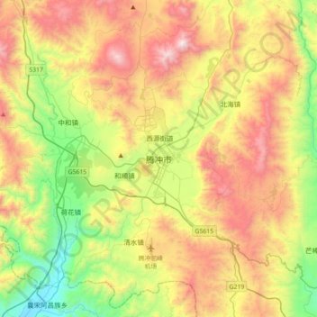
Name: Topografische Karte Tengchong, Höhe, Relief.
Ort: Tengchong, Baoshan, Yunnan, 679100, China (24.86840 98.33368 25.18840 98.65368)
Durchschnittliche Höhe: 1.770 m
Minimale Höhe: 1.059 m
Maximale Höhe: 2.715 m
Situated at the southwestern end of the (transversely faulted) Hengduan Mountains, Tengchong topographically assumes the form of a horseshoe with the opening facing the south. The easternmost sources of the Irrawaddy River issue from the high mountains at the summit of Mount Danaozi of Gaoligong Mountain, 3,780.2 m (12,402 ft) above sea level and the lowest point, 930 m (3,050 ft) above sea level, is in the Suqingjiang valley. The elevation of the city seat is 1,640 m (5,380 ft).