
Topografische Karte lac Seul
Klicken Sie auf die Karte, um die Höhe anzuzeigen.
lac Seul
Lac Seul is a large, crescent shaped reservoir in Kenora District, northwestern Ontario, Canada. It is approximately 241 km (150 mi) long. It has a maximum (regulated) depth of 47.2 m, with a surface elevation of 357 m above sea level. Its level is raised in the summer and then drawn down in the winter months to reach points of as low as 16 feet below the maximum level. It is the second largest body of water entirely within the province of Ontario (Lake Nipigon being first). The lake consists of open water bays, narrow channels, and islands. It is a relatively shallow lake with many rock shoals. This provides a good habitat for walleye (also known as "yellow pickerel") and northern pike as well as yellow perch. During the Lac Seul project of 1968-1972 no muskelunge were noted in the catches of research nets set over those years. Significant numbers of whitefish, tullibee, burbot and cisco were noted as well although they infrequently were noted in the sport fishery. Lac Seul is noted for offering some of the best fishing in Ontario.
Über diese Karte
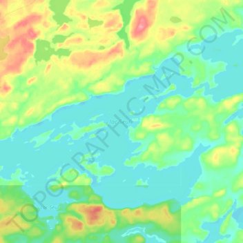
Name: Topografische Karte lac Seul, Höhe, Relief.
Durchschnittliche Höhe: 374 m
Minimale Höhe: 351 m
Maximale Höhe: 431 m
Andere topografische Karten
Klicken Sie auf eine Karte, um ihre Topografie, ihre Höhe und ihr Relief anzuzeigen.
Cardinal (Lac) Lake
Canada > Ontario > Kenora District > Unorganized Kenora District
Durchschnittliche Höhe: 392 m
Canyon Lake
Canada > Ontario > Kenora District > Unorganized Kenora District
Durchschnittliche Höhe: 405 m
Shoal Lake
Canada > Ontario > Kenora District > Unorganized Kenora District
Durchschnittliche Höhe: 325 m
Wolf Island
Canada > Ontario > Kenora District > Unorganized Kenora District
Durchschnittliche Höhe: 327 m
Burditt Lake
Canada > Ontario > Kenora District > Unorganized Kenora District
Durchschnittliche Höhe: 367 m
Wabigoon
Canada > Ontario > Kenora District > Unorganized Kenora District
Durchschnittliche Höhe: 381 m
Hudson Bay Lowlands
Canada > Ontario > Kenora District > Unorganized Kenora District
Durchschnittliche Höhe: 17 m
Dinorwic
Canada > Ontario > Kenora District > Unorganized Kenora District
Durchschnittliche Höhe: 383 m
Big Island Lake
Canada > Ontario > Kenora District > Unorganized Kenora District
Durchschnittliche Höhe: 430 m
Arpin Lake
Canada > Ontario > Kenora District > Unorganized Kenora District
Durchschnittliche Höhe: 383 m
Carroll Lake
Canada > Ontario > Kenora District > Unorganized Kenora District
Durchschnittliche Höhe: 338 m
Beauty Lake
Canada > Ontario > Kenora District > Unorganized Kenora District
Durchschnittliche Höhe: 348 m
Clearwater Bay
Canada > Ontario > Kenora District > Unorganized Kenora District
Durchschnittliche Höhe: 334 m
Boyne Lake
Canada > Ontario > Kenora District > Unorganized Kenora District
Durchschnittliche Höhe: 361 m
Slate Falls
Canada > Ontario > Kenora District > Unorganized Kenora District
Durchschnittliche Höhe: 385 m
Wabauskang 21
Canada > Ontario > Kenora District > Unorganized Kenora District
Durchschnittliche Höhe: 368 m
Dingwall Island
Canada > Ontario > Kenora District > Unorganized Kenora District
Durchschnittliche Höhe: 325 m
Ena Lake
Canada > Ontario > Kenora District > Unorganized Kenora District
Durchschnittliche Höhe: 350 m
Granite Lake
Canada > Ontario > Kenora District > Unorganized Kenora District
Durchschnittliche Höhe: 355 m
Oxdrift
Canada > Ontario > Kenora District > Unorganized Kenora District
Durchschnittliche Höhe: 364 m
Gordon Island
Canada > Ontario > Kenora District > Unorganized Kenora District
Durchschnittliche Höhe: 349 m
Twin Lake
Canada > Ontario > Kenora District > Unorganized Kenora District
Durchschnittliche Höhe: 399 m
Clear Lake
Canada > Ontario > Kenora District > Unorganized Kenora District
Durchschnittliche Höhe: 367 m
Grindstone Lake
Canada > Ontario > Kenora District > Unorganized Kenora District
Durchschnittliche Höhe: 371 m
Look Lake
Canada > Ontario > Kenora District > Unorganized Kenora District
Durchschnittliche Höhe: 393 m
Warwick Lake
Canada > Ontario > Kenora District > Unorganized Kenora District
Durchschnittliche Höhe: 341 m
West Arm
Canada > Ontario > Kenora District > Unorganized Kenora District
Durchschnittliche Höhe: 379 m
Slate Islands
Canada > Ontario > Kenora District > Unorganized Kenora District
Durchschnittliche Höhe: 322 m
Nine Mile Lake
Canada > Ontario > Kenora District > Unorganized Kenora District
Durchschnittliche Höhe: 413 m
Mills Lake
Canada > Ontario > Kenora District > Unorganized Kenora District
Durchschnittliche Höhe: 380 m
Betula Lake
Canada > Ontario > Kenora District > Unorganized Kenora District
Durchschnittliche Höhe: 371 m
Chisholm Island
Canada > Ontario > Kenora District > Unorganized Kenora District
Durchschnittliche Höhe: 323 m
Muskeg River
Canada > Ontario > Kenora District > Unorganized Kenora District
Durchschnittliche Höhe: 357 m
Mackey Island
Canada > Ontario > Kenora District > Unorganized Kenora District
Durchschnittliche Höhe: 336 m
Muskeg River
Canada > Ontario > Kenora District > Unorganized Kenora District
Durchschnittliche Höhe: 363 m
Tablerock Lake
Canada > Ontario > Kenora District > Unorganized Kenora District
Durchschnittliche Höhe: 384 m
Thaddeus
Canada > Ontario > Kenora District > Unorganized Kenora District
Durchschnittliche Höhe: 411 m
Little Boulder Lake
Canada > Ontario > Kenora District > Unorganized Kenora District
Durchschnittliche Höhe: 359 m
Cameron Island
Canada > Ontario > Kenora District > Unorganized Kenora District
Durchschnittliche Höhe: 338 m