
Topografische Karte Fort MacKay
Interaktive Karte
Klicken Sie auf die Karte, um die Höhe anzuzeigen.
Über diese Karte
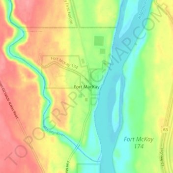
Name: Topografische Karte Fort MacKay, Höhe, Relief.
Ort: Fort MacKay, Wood Buffalo, Alberta, T0P 1C0, Canada (57.16257 -111.65784 57.20257 -111.61784)
Durchschnittliche Höhe: 265 m
Minimale Höhe: 228 m
Maximale Höhe: 306 m
Fort McKay (/məˈkaɪ/ mə-KY) or Fort MacKay is a community in northeast Alberta, Canada that is located at the confluence of the Athabasca and MacKay rivers. It is approximately 54 km (34 mi) north of Fort McMurray via Highway 63 and Fort McKay Road. The community has an elevation of 260 m (850 ft).