
Topografische Karte Durbin
Klicken Sie auf die Karte, um die Höhe anzuzeigen.
Über diese Karte
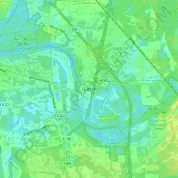
Name: Topografische Karte Durbin, Höhe, Relief.
Ort: Durbin, Saint Johns County, Florida, 33359, United States (30.06077 -81.55937 30.14077 -81.47937)
Durchschnittliche Höhe: 7 m
Minimale Höhe: 1 m
Maximale Höhe: 16 m
Andere topografische Karten
Klicken Sie auf eine Karte, um ihre Topografie, ihre Höhe und ihr Relief anzuzeigen.
Saint Augustine
United States > Florida > Saint Johns County
Saint Augustine is characterized by a diverse topography that features a mix of coastal and inland landscapes. Situated along the eastern coast of the state, the city lies on a narrow peninsula bordered by the Atlantic Ocean to the east and the Matanzas River to the west. The area includes sandy beaches that…
Durchschnittliche Höhe: 5 m
Palm Valley
United States > Florida > Saint Johns County > Ponte Vedra Beach
Durchschnittliche Höhe: 4 m
Butler Beach
United States > Florida > Saint Johns County > Saint Augustine Beach
Durchschnittliche Höhe: 3 m
Butler Beach
United States > Florida > Saint Johns County > Saint Augustine Beach
Durchschnittliche Höhe: 2 m
Villano Beach
United States > Florida > Saint Johns County > Villano Beach
Durchschnittliche Höhe: 1 m
Butler Beach
United States > Florida > Saint Johns County > Saint Augustine Beach
Durchschnittliche Höhe: 3 m
DeLeon Shores Park
United States > Florida > Saint Johns County > Ponte Vedra Beach > Palm Valley
Durchschnittliche Höhe: 4 m
Butler Beach
United States > Florida > Saint Johns County > Saint Augustine
Durchschnittliche Höhe: 3 m
Palm Valley
United States > Florida > Saint Johns County > Ponte Vedra Beach
Durchschnittliche Höhe: 4 m